Biking Across the USA - September Diary
|
|
Wednesday 1st September 2004
 From
Seaside to Fort Stevens State Park, Camping Area. About 18 miles on route.
After an enormous amount of pancakes at the Pig'N Pancake, a visit to a
second hand bookshop, and a bit of staring at the sea, we finally got on
the road and we've made it all the enormous distance of 18 miles to Fort
Stevens. This was entirely along route 101 apart from the very last few
miles to the campsite, so a busy road, including one puncture (actually
a 'squeeze' puncture, not a real one - the specialized armadillo tyre on
the back of my (Steve's) bike, has never puncture and each one lasts about
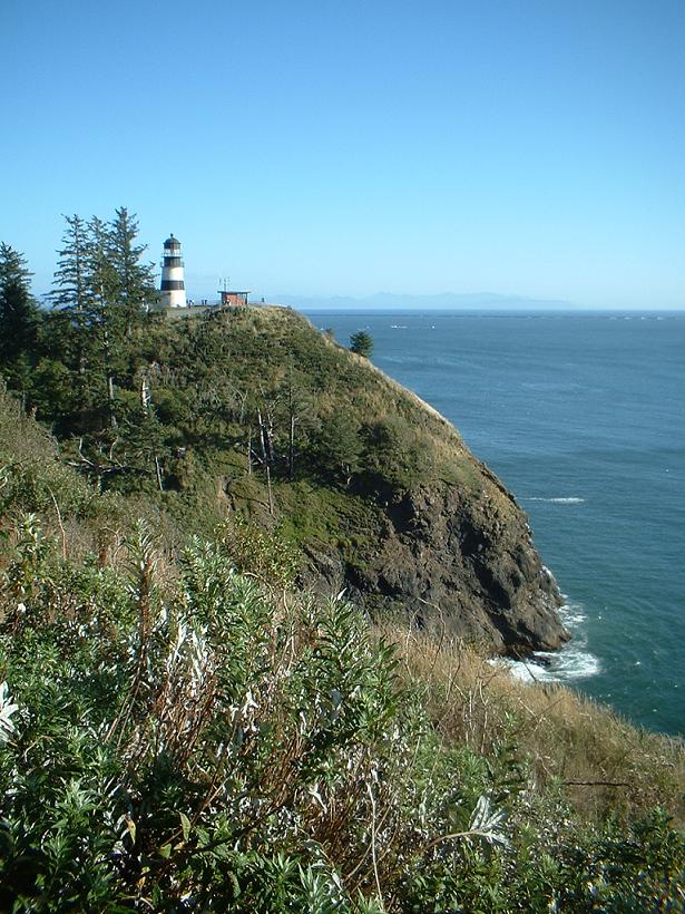
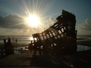
3000 miles). We headed onto the beach at Fort Stevens, and discovered the
huge and empty beach. The wreck of an old British steamer lies on the shore
- it's made of iron so it's not decaying very quickly. Pictures show that
it has lost a fair bit of its structure just in the last few years though.
A wonderful elemental place. From
Seaside to Fort Stevens State Park, Camping Area. About 18 miles on route.
After an enormous amount of pancakes at the Pig'N Pancake, a visit to a
second hand bookshop, and a bit of staring at the sea, we finally got on
the road and we've made it all the enormous distance of 18 miles to Fort
Stevens. This was entirely along route 101 apart from the very last few
miles to the campsite, so a busy road, including one puncture (actually
a 'squeeze' puncture, not a real one - the specialized armadillo tyre on
the back of my (Steve's) bike, has never puncture and each one lasts about
3000 miles). We headed onto the beach at Fort Stevens, and discovered the
huge and empty beach. The wreck of an old British steamer lies on the shore
- it's made of iron so it's not decaying very quickly. Pictures show that
it has lost a fair bit of its structure just in the last few years though.
A wonderful elemental place. |
|
Thursday 2nd September 2004
 From
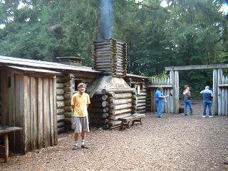
Fort Stevnes to, well, Fort Stevens. A day exploring Fort Clatsop - where
the first explorers of the region stayed over the winter of 1805-06 - Lewis
and Clark. First Explorers? Well, there were the native americans before
them, and the British explorer Mackenzie did the transContinental crossing
before them too! But we'll let the americans deceive themselves with this
hype. It's an impressive achievement. We met Laura and Ned who are doing
the Pacific Coast to San Diego - just starting out, really. Wise going south
at this time of year. We breakfasted and then went to lunch (it was a very
late breakfast) and then went to Fort Clatsop, the Lewis and Clark base
for winter of 1805-6. It was fascinating and was the usual reconstruction
of the original camp - which decayed long ago being made of wood. The camp
was impressive, but perhaps the setting is rather more impressive since
it is a wonderful forest - huge trees, including some huge red cedars. The
gift shop was interesting - I searched for chocolates, being a hugry cyclist,
and failed to find any. I guess I should contact their merchandising department
- why are there no Lewis and Clark commemorative chocolates - it seems like
an oversight to me. But then, the cyclists's priorities are rarely those
of the general public. We cycled to the point at which the Columbia River
meets the Pacific - a tremendous place of rushing clouds and surging seas
- with quite a gale blowing and thus messing up the surf as usual. Guy's
tooth is playing up again - the tooth that he got fixed back in Lander. From
Fort Stevnes to, well, Fort Stevens. A day exploring Fort Clatsop - where
the first explorers of the region stayed over the winter of 1805-06 - Lewis
and Clark. First Explorers? Well, there were the native americans before
them, and the British explorer Mackenzie did the transContinental crossing
before them too! But we'll let the americans deceive themselves with this
hype. It's an impressive achievement. We met Laura and Ned who are doing
the Pacific Coast to San Diego - just starting out, really. Wise going south
at this time of year. We breakfasted and then went to lunch (it was a very
late breakfast) and then went to Fort Clatsop, the Lewis and Clark base
for winter of 1805-6. It was fascinating and was the usual reconstruction
of the original camp - which decayed long ago being made of wood. The camp
was impressive, but perhaps the setting is rather more impressive since
it is a wonderful forest - huge trees, including some huge red cedars. The
gift shop was interesting - I searched for chocolates, being a hugry cyclist,
and failed to find any. I guess I should contact their merchandising department
- why are there no Lewis and Clark commemorative chocolates - it seems like
an oversight to me. But then, the cyclists's priorities are rarely those
of the general public. We cycled to the point at which the Columbia River
meets the Pacific - a tremendous place of rushing clouds and surging seas
- with quite a gale blowing and thus messing up the surf as usual. Guy's
tooth is playing up again - the tooth that he got fixed back in Lander. |
|
Friday 3rd September 2004
Still at Fort Stevens, but a day when we finally visited Astoria and
so completed the official transAm route. We originally intended to go
by bus, but the first bus we missed by seconds, arriving at the road slightly
too late, the second bus we misidentified as an RV (Recreational Vehicle)
- but it was the bus, so it flew by at speed. At this point we decided
to cycle - inspite of a pedal starting to grind on Steve's bike. Well,
we headed in, haggled with a bike shop to get some lithium grease and
ball bearings for a pedal, and then went round the book shops. Steve now
has an excess of cat mysteries and is carrying a small library. Perhaps
I could become a mobile library for the Oregon coast? Surfing while the
customers browsed?
 Astoria
is quite an alternative place - in one bookshop a man, Dave, was doing
psychic readings in amidst the bookshelves. He chatted to us and revealed
that he had just had a reading that said he should go and live in Wales.
he asked us where might be suitable. Immediately we both thought of Machynlleth
and said he'd fit in nicely amidst the wind turbines and incense sticks.
He wrote it down and said he'd try the area. Just after that, a Welshman
walked into the shop, a surprising event in the middle of Oregon, and
we left Dave and a new found friend discussing the merits of various locations
in Wales. (at this point in the original version of this page, my computer
timed me out in Aberdeen, Washington, library - "I need to find a
friendly library"). The narrative was then completed in the library
at Montesano... Guy found a dentist in Astoria that examined his teeth
for free! This was a true miracle, and ended with a prescription that
brought colour into Guy's cheeks and joy back into his heart (he's been
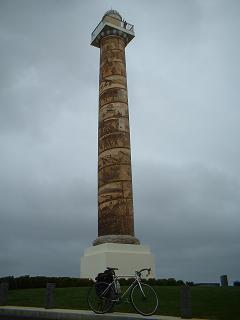
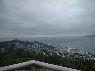
like a sick dog when his tooth hurt). Finally we climhed the Astoria column,
set high on a hill overlooking the town, and felt dizzy at the height.
The column marks the end of the transAm official route. In the photo you
may be able to make out Guy, waving (and feeling dizzy) at the very top
of the tower. We cycled back to Fort Stevens and watched the sun go down
over the churning sea at the end of the Columbia River, looking out towards
the distance Cape Disappointment, where we hoped to go tomorrow. Astoria
is quite an alternative place - in one bookshop a man, Dave, was doing
psychic readings in amidst the bookshelves. He chatted to us and revealed
that he had just had a reading that said he should go and live in Wales.
he asked us where might be suitable. Immediately we both thought of Machynlleth
and said he'd fit in nicely amidst the wind turbines and incense sticks.
He wrote it down and said he'd try the area. Just after that, a Welshman
walked into the shop, a surprising event in the middle of Oregon, and
we left Dave and a new found friend discussing the merits of various locations
in Wales. (at this point in the original version of this page, my computer
timed me out in Aberdeen, Washington, library - "I need to find a
friendly library"). The narrative was then completed in the library
at Montesano... Guy found a dentist in Astoria that examined his teeth
for free! This was a true miracle, and ended with a prescription that
brought colour into Guy's cheeks and joy back into his heart (he's been
like a sick dog when his tooth hurt). Finally we climhed the Astoria column,
set high on a hill overlooking the town, and felt dizzy at the height.
The column marks the end of the transAm official route. In the photo you
may be able to make out Guy, waving (and feeling dizzy) at the very top
of the tower. We cycled back to Fort Stevens and watched the sun go down
over the churning sea at the end of the Columbia River, looking out towards
the distance Cape Disappointment, where we hoped to go tomorrow.
|
|
Saturday 4th September 2004
 From
Fort Stevens to Cape Disappointment State Park, Washington State. About
30 miles. We cycled back into Astoria, where Steve went round the maritime
museum and was delighted witht he tales of daring on the high seas - the
Columbia River meets the Pacific Ocean and creates a very turbulent sea.
Excellent for sea rescues, wrecks, and tumbling waves, and Les Galloway's
excellent book "Forty Fathoms Deep" was bought from the musueum shop.
More books were bought at Lucy's Books, so the bikes have got even heavier.
Food now has to be bungeed to the bike, since there's no room for anything
more within the panniers. We ate lunch at the Pig 'N Pancake (specialists
in pancakes - wonderful levels of carbohydrates!) before setting out over
the Astoria Bridge - which is about 4 miles long and stretches out over
the Columbia River - you can see the slender darkness of the bridge against
the river surface in the photo. There's not much room for bikes up there,
and the wind was blowing strongly. It's a wonderful bridge to ride across
though - you feel suspended above the river on a little strip of metal
and tarmac. I watched a fisherman hauling in a fish yards from my place
on the tarmac. From
Fort Stevens to Cape Disappointment State Park, Washington State. About
30 miles. We cycled back into Astoria, where Steve went round the maritime
museum and was delighted witht he tales of daring on the high seas - the
Columbia River meets the Pacific Ocean and creates a very turbulent sea.
Excellent for sea rescues, wrecks, and tumbling waves, and Les Galloway's
excellent book "Forty Fathoms Deep" was bought from the musueum shop.
More books were bought at Lucy's Books, so the bikes have got even heavier.
Food now has to be bungeed to the bike, since there's no room for anything
more within the panniers. We ate lunch at the Pig 'N Pancake (specialists
in pancakes - wonderful levels of carbohydrates!) before setting out over
the Astoria Bridge - which is about 4 miles long and stretches out over
the Columbia River - you can see the slender darkness of the bridge against
the river surface in the photo. There's not much room for bikes up there,
and the wind was blowing strongly. It's a wonderful bridge to ride across
though - you feel suspended above the river on a little strip of metal
and tarmac. I watched a fisherman hauling in a fish yards from my place
on the tarmac.
 Eventually
we were in Washington State , and we headed along the coast road to Cape
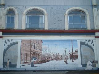
Disappointment, which we weren't. Just before the disappointment, there
was the small town of Ilwaco, which has some good wall murals. I particularly
like the one that combined historical and contemporary, as a boy carrying
a skateboard walks into a scene from the 19th Century! (click on the photo
for a bigger picture). The state parks in Washington are not as good as
the state parks in Oregon - the facilities are more basic and seem a bit
less clean and tidy. Due to the numbers of Racoons around the tent, we
slept with our food all around us. Eventually
we were in Washington State , and we headed along the coast road to Cape
Disappointment, which we weren't. Just before the disappointment, there
was the small town of Ilwaco, which has some good wall murals. I particularly
like the one that combined historical and contemporary, as a boy carrying
a skateboard walks into a scene from the 19th Century! (click on the photo
for a bigger picture). The state parks in Washington are not as good as
the state parks in Oregon - the facilities are more basic and seem a bit
less clean and tidy. Due to the numbers of Racoons around the tent, we
slept with our food all around us.
|
|
Sunday 5th September 2004
 A
day exploring Cape Disappointment. After a heap of trivialities, such
as having to do some laundry (there's a remarkable variation amongst transAm
cyclists in their cleanliness - some seem just about never to wash anything
at all, either themselves or their clothes, others look like they are
permanently freshly luanderied), we went to Waikiki Beach, on the River
Columbia side of the headland, and Steve swam. the river water is warmer
than the sea - much warmer. It's quite a hearable temperature. I'm a bit
puzzled about the sea temperatures - there's a Japanese current coming
in which warms things up, and Alaskan current flowing down the coast which
cools it all down, and river currents which warm it up. Apparently the
sea is warmer as you go offshore into the Japanese current! Cape Disappointment
itself is beautiful, a lighthouse on a rocky headland, surrounded by forests,
and looking every bit as romantic as its name requires it should. Fortunately
it isn't open to the public so it doesn't reveal its romantic secrets
to be just a heap of metal and wiring. We ended the day watching the turbulent
Columbia crashing into the Pacific waves, this time from the north side
of the Columbia, by the heap of rocks that form the north jetty. In the
photo, you can see the lighthouse, but in the distance you can see (just
about) the north jetty jutting way out into the Pacific, and the Oregon
coast beyond that, where we were a couple of days ago. Click on the photo
and you'll get a more detailed pcture. A
day exploring Cape Disappointment. After a heap of trivialities, such
as having to do some laundry (there's a remarkable variation amongst transAm
cyclists in their cleanliness - some seem just about never to wash anything
at all, either themselves or their clothes, others look like they are
permanently freshly luanderied), we went to Waikiki Beach, on the River
Columbia side of the headland, and Steve swam. the river water is warmer
than the sea - much warmer. It's quite a hearable temperature. I'm a bit
puzzled about the sea temperatures - there's a Japanese current coming
in which warms things up, and Alaskan current flowing down the coast which
cools it all down, and river currents which warm it up. Apparently the
sea is warmer as you go offshore into the Japanese current! Cape Disappointment
itself is beautiful, a lighthouse on a rocky headland, surrounded by forests,
and looking every bit as romantic as its name requires it should. Fortunately
it isn't open to the public so it doesn't reveal its romantic secrets
to be just a heap of metal and wiring. We ended the day watching the turbulent
Columbia crashing into the Pacific waves, this time from the north side
of the Columbia, by the heap of rocks that form the north jetty. In the
photo, you can see the lighthouse, but in the distance you can see (just
about) the north jetty jutting way out into the Pacific, and the Oregon
coast beyond that, where we were a couple of days ago. Click on the photo
and you'll get a more detailed pcture.
We have a short
mpeg video clip (154Kb so OK for 56K modems - ogg available for those that
are wise enough to prefer linux and open source), surveying the Pacific Ocean
and the Columbia River, with commentary. Quicktime usually defaults to
too low a volume - so if that's what you're using, you may need to turn
up the volume.
|
|
Monday 6th September 2004
 From
Cape Disappointment State Park to Grayland Beach State Park, a total of
about 75 miles. We breakfasted with deer around us, unconcerned by our presence.
They included a small baby deer and its mother. We hurtled off along the
coast highway 101. This is not a pleasant road, and today being the end
of the holidays no doubt made it worse. One car turned right was it was
overtaking me, forcing me to rapidly abandon the highway altogether to avoid
a collision! Another vehicle through a plastic drinks bottle at Guy, which
hit him but fortunately didn't knock him off the road. The scenery is lovely
- gentle wooded hills, with expanses of muddy inlets opening out between
the trees. A delightful scene. We eventually reached South Bend where we
had lunch and watched the Labor Day festivities - mostly a matter of eating
a huge amount of burgers and sugary confections. Then we pushed on to Raymond,
crossed the bridge, and headed out to the Pacific Beaches again, on the
much quieter highway 105, eventually reaching Grayland Beach as it was getting
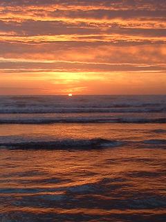
a bit dark. We did just have time to see an excellent sunset, full of orange
and pink streaks against a dark blue. We pitched the tent in darkness, and
it was only in the morning that I (Steve) discovered that I'd been sleeping
in a tent that was pitched over a dead mouse (perhaps it was alive when
we pitched?). From
Cape Disappointment State Park to Grayland Beach State Park, a total of
about 75 miles. We breakfasted with deer around us, unconcerned by our presence.
They included a small baby deer and its mother. We hurtled off along the
coast highway 101. This is not a pleasant road, and today being the end
of the holidays no doubt made it worse. One car turned right was it was
overtaking me, forcing me to rapidly abandon the highway altogether to avoid
a collision! Another vehicle through a plastic drinks bottle at Guy, which
hit him but fortunately didn't knock him off the road. The scenery is lovely
- gentle wooded hills, with expanses of muddy inlets opening out between
the trees. A delightful scene. We eventually reached South Bend where we
had lunch and watched the Labor Day festivities - mostly a matter of eating
a huge amount of burgers and sugary confections. Then we pushed on to Raymond,
crossed the bridge, and headed out to the Pacific Beaches again, on the
much quieter highway 105, eventually reaching Grayland Beach as it was getting
a bit dark. We did just have time to see an excellent sunset, full of orange
and pink streaks against a dark blue. We pitched the tent in darkness, and
it was only in the morning that I (Steve) discovered that I'd been sleeping
in a tent that was pitched over a dead mouse (perhaps it was alive when
we pitched?). |
|
Tuesday 7th September 2004
From Grayland Beach State Park to Lake Sylvia State Park. A grand total
of 37 miles. Since we are now going to have to leave the Pacific, we spend
the morning lying on the beach admiring the waves and being shocked by the
sheer coldness of the sea. We breakfasted at a cafe with a chart of the
local sea area on its wall - and noticed how the sea deepens rapdily from
the coastal paddling waters to a depth of a mile only a few miles offshore.
There are oozy chasms out there, canyons of blackness to match the ones
on shore. Eventually headed to Aberdeen, which seemed a pretty depressed
and depressing place relieved only by a pleasant library with a dragon like
internet access policy (chucked off after 15 mins). Then on, in diminishing
sunlight, along highway 12, which rushed us, amidst dense traffic, to Montesano,
where, with the help of a very kind local librarian, we found our campsite
in semi-darkness. Lake Sylvia is a picturesque small winding lake, set in
a forest, just on the edge of Montesano. Since today is Guy's birthday,
we ate a meal of Wheat Beer and Olive Pate (Guy's delightful preferred food).
I found my way back to Montesano library delighting in their kindly internet
access policy the very next day (this kindliness is limited by the fact
that the CD drive was disabled, the various ports to plug thing into (e.g.
USB) were unavailable, and you couldn't download anything from anywhere
- it must be a virus filled nightmare that they're living...). |
|
Wednesday 8th September 2004
From Lake Sylvia State Park to Belfair State Park, 69.5 miles, according
to my pedometer (though about 5 of those miles were cycled when completely
lost in the city of Shelton). Today was a day of steady rain. It wasn't
cold, and the scenery is pretty, being a series of wooded shallow valleys,
some with lakes in. The heavy traffic and rain didn't make it so scenic
however. After a breakfast supplied by the local Thriftway, and a glance
at the local library's maps (which showed that the road we'd initially thought
we'd take, past Shafer State Park, was gravel and that we'd likely as not
get very lost - so we took a simpler route) we sped out of town on the road
that parallels the dual carriageway/interstate, going NE. Eventually reached
McCleary, where we headed over to Shelton. In Shelton we got very lost,
and passed through the town centre three times before finally getting out
of the town on Highway 3 North (by which time it was getting late at 4.30pm).
Guy slipped on some railroad tracks and fell off, on one of our abortive
attempts to leave Shelton by the right road. A man nearby said that he'd
seen many a cyclist slip off there - the tracks cross the road at a sharp
angle, not the preferred 90 degrees - "They all do that! We had one with
a broken hip once, we had to take him to hospital" to quote! Some locals
stared at Guy, lying in the road and then brushing himself off, but none
helped nor did anyone enquire whether he was OK. Even the dogs, which barked
endlessly, weren't quietened down, but just allowed to bark and bark. I
don't have a good image of Shelton! - it may be a nice town, but it could
sure use some traffic signs and a bit of cycle friendly road design! We
reached Belfair as it was getting dark and headed into a Chinese restaurant
- which seem to be an excellent deal for vegetarians in the USA since they've
always got tofu on the menu. Then on, with lights on, to Belfair State Park
(3 miles out of town), where we pitched up in darkness in a woodland glade.
|
|
Thursday 9th September 2004
 From
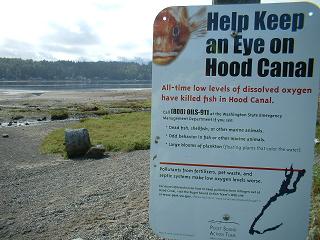
Belfair State Park to Bainbridge Island - about 30 miles. We had a look
at the Hood Canal - the long channels of water that wind around from Puget
Sound deep into the hills of the Olympic Peninsula. There's some kind of
eco-disaster happening by the look of it - as the photo indicates. But it
all looks so picturesque that we didn't notice the dead fish. Then we headed
to Bremerton, going past some very impressive naval dockyards packed with
huge aircraft carriers and warships, and waited for the ferry. The rain
eventually went and the day turned hot. Good weather for drying everything
out. The ferry was at 3pm until it got cancelled due to "mechanical
problems" - and we then caught the 4.15 sailing. I typed up my diary
in the usual delightful library - this time Bremerton Public Library. Later...
we got the ferry at 4.15pm and then got another ferry than got us to Bainbridge
Island at about 6pm. We headed for Fay Bainbridge State Park, which has
a hiker/biker camping section, where we now are. Finding Fay Bainbridge
State Park was not easy in the semi darkness. We missed it initially and
went a mile further until we realized it couldn't possibly be this far.
The houses on the island are most large detached houses with acres of ground,
and often some fencing, around them. So it's difficult to ask directions.
People travel by car, so there's really no-one to ask where the State Park
is. The State Park is a bit mean because it puts the hiker/bikers away from
the pleasant bit of shoreline, offering them the delights of a rather steep
hill to camp on. Still, we were the only ones camping and it was a quiet
and nicely secluded spot. From
Belfair State Park to Bainbridge Island - about 30 miles. We had a look
at the Hood Canal - the long channels of water that wind around from Puget
Sound deep into the hills of the Olympic Peninsula. There's some kind of
eco-disaster happening by the look of it - as the photo indicates. But it
all looks so picturesque that we didn't notice the dead fish. Then we headed
to Bremerton, going past some very impressive naval dockyards packed with
huge aircraft carriers and warships, and waited for the ferry. The rain
eventually went and the day turned hot. Good weather for drying everything
out. The ferry was at 3pm until it got cancelled due to "mechanical
problems" - and we then caught the 4.15 sailing. I typed up my diary
in the usual delightful library - this time Bremerton Public Library. Later...
we got the ferry at 4.15pm and then got another ferry than got us to Bainbridge
Island at about 6pm. We headed for Fay Bainbridge State Park, which has
a hiker/biker camping section, where we now are. Finding Fay Bainbridge
State Park was not easy in the semi darkness. We missed it initially and
went a mile further until we realized it couldn't possibly be this far.
The houses on the island are most large detached houses with acres of ground,
and often some fencing, around them. So it's difficult to ask directions.
People travel by car, so there's really no-one to ask where the State Park
is. The State Park is a bit mean because it puts the hiker/bikers away from
the pleasant bit of shoreline, offering them the delights of a rather steep
hill to camp on. Still, we were the only ones camping and it was a quiet
and nicely secluded spot. |
|
Friday 10th September 2004
 A
day in Seattle - about 15 miles of cycling around. We eventually got the
11.30am ferry to Seattle and managed not to go to the Seattle Art Museum,
due to a huge queue (I think they were queueing for the Van Gogh exhibition,
but it's all one huge queue so it's hard to tell). The main focus of the
day was bookshops - Elliot Bay Books and Arundel Books (on 1st Avenue) being
particularly delightful. We also visited the Pike's Brewery and Pub right
next to the Hostelling International Hostel. Seattle struck us as rather
like Leeds to look at - but with better shops and by the sea (well, Puget
sound). It certainly looks impressive as you come in from the sound, and
reminded me of appraoching Sydney(Australia) - with the lines of ferry terminals
right near the middle of the city. We did see it in the rain, fortunately,
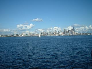
since that is it's classic appearance apparently. Seattle is not particularly
bike friendly in the centre - there are very few bike lanes and the traffic
is pretty constant. In the evening we headed back to Bainbridge Island on
the ferry (35 min crossing), and tried out Pike Brewery's finest back at
the campsite. One of Pike Brewery's most notable ales is the 'Kilt Lifter'!
- apparently it's a true scottish style beer. Kilts are a bit of an institution
in Seattle, we saw a few around the streets. The colours were not always
clan colours but rather arty fabric creations - and we only saw men wearing
them. Beats shorts for coolness no doubt. A
day in Seattle - about 15 miles of cycling around. We eventually got the
11.30am ferry to Seattle and managed not to go to the Seattle Art Museum,
due to a huge queue (I think they were queueing for the Van Gogh exhibition,
but it's all one huge queue so it's hard to tell). The main focus of the
day was bookshops - Elliot Bay Books and Arundel Books (on 1st Avenue) being
particularly delightful. We also visited the Pike's Brewery and Pub right
next to the Hostelling International Hostel. Seattle struck us as rather
like Leeds to look at - but with better shops and by the sea (well, Puget
sound). It certainly looks impressive as you come in from the sound, and
reminded me of appraoching Sydney(Australia) - with the lines of ferry terminals
right near the middle of the city. We did see it in the rain, fortunately,
since that is it's classic appearance apparently. Seattle is not particularly
bike friendly in the centre - there are very few bike lanes and the traffic
is pretty constant. In the evening we headed back to Bainbridge Island on
the ferry (35 min crossing), and tried out Pike Brewery's finest back at
the campsite. One of Pike Brewery's most notable ales is the 'Kilt Lifter'!
- apparently it's a true scottish style beer. Kilts are a bit of an institution
in Seattle, we saw a few around the streets. The colours were not always
clan colours but rather arty fabric creations - and we only saw men wearing
them. Beats shorts for coolness no doubt. |
Saturday 11th September
 Our
final full day in the USA and a day devoted to shopping for relatives, for
the most part, plus a few more books shoved in as well, to the extent that
I, Steve, am now carrying a ridiculous number of books and am throwing away
clothes in order to make room. Yes, socks that are almost worn through,
shorts that look a bit ragged, they've all gone, to make way for a splurge
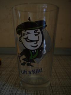
of shopping. One item bought was the glass in the photo - a rather nice
depiction of a Scotsman courtesy of the Pike Brewery. Once again a huge
queue prevented us from getting into the Seattle Art Museum. Instead we
spent time in several bookshops - trying to choose just the number of books
that could, without finally splitting the seams of our panniers, be got
into our baggage. Seattle was under cloud a good deal of the time - which
made it look rather more spectacular from the sea as we came in to the dock.
The atmosphere of Seattle is very pleasant - so like the UK in weather,
not too hot, not too cold, and full of coffee shops. We ended our final
day in the USA by visiting the Pyramid brewing company, out in the south
of the city centre, right by two huge stadia (one baseball, one for american
football) that looked like something out of Star Wars. Pyramid Ales are
excellent, but we had a ferry to catch followed by a bike ride in semi-darkness
so our sampling was somewhat restricted. Our
final full day in the USA and a day devoted to shopping for relatives, for
the most part, plus a few more books shoved in as well, to the extent that
I, Steve, am now carrying a ridiculous number of books and am throwing away
clothes in order to make room. Yes, socks that are almost worn through,
shorts that look a bit ragged, they've all gone, to make way for a splurge
of shopping. One item bought was the glass in the photo - a rather nice
depiction of a Scotsman courtesy of the Pike Brewery. Once again a huge
queue prevented us from getting into the Seattle Art Museum. Instead we
spent time in several bookshops - trying to choose just the number of books
that could, without finally splitting the seams of our panniers, be got
into our baggage. Seattle was under cloud a good deal of the time - which
made it look rather more spectacular from the sea as we came in to the dock.
The atmosphere of Seattle is very pleasant - so like the UK in weather,
not too hot, not too cold, and full of coffee shops. We ended our final
day in the USA by visiting the Pyramid brewing company, out in the south
of the city centre, right by two huge stadia (one baseball, one for american
football) that looked like something out of Star Wars. Pyramid Ales are
excellent, but we had a ferry to catch followed by a bike ride in semi-darkness
so our sampling was somewhat restricted. |
Sunday 12th September
 We
headed across to Seattle with our bikes. The bus to the airport leaves from
near University Street - we sorted this out the day before. But when we
tried to get our bikes on the bus we were told that the bike carriage zone
only begins outside of the city centre free bus zone. No doubt the city
planners can't see why anyone would want to use a bike in the city centre
when the bus is free. But if you've got a bike to get out to the suburbs
to catch a plane, the policy seems a bit dumb. A sorry look persuaded the
driver to apply commonsense, fortunately, so we were allowed on straightaway.
The ride to the airport (SeaTac) takes you through the usual US urban sprawl,
though it's interesting to see the giant hangars and offices of Boeing.
At the airport we dutifully wrapped our bike in the shredded remnants of
Guy's sleeping mat - the bubbles have been popping ever since we started
so it's now no more than a bit of tough plastic (as Steve says - the USA
has taken the bubbles out of Guy's life) - and, along with a plastic bike
bag supplied by BA (we thought these no longer existed but they do, at the
moment, in Seattle!), we wrapped up our bikes. Then we joined a ridiculously
long queue for the 'plane. BA had a little queue for Club Class and for
World Traveller Plus, but a queue that lasted two hours (of queuing time
per person) for the ordinary bulk of the passengers - World Traveller class.
Ridiculous!!! I managed to read a substantial chunk of a novel while queueing.
Hey, British Airways, why not take a tip from the deli counter at Sainsbury's
and give out numbered tickets if you're going to make people queue for such
a ridiculously long time?! A pity, since BA handled the bikes very well
and the flights were on time or early. The flight back was fun - but unfortunately
we didn't apply ourselves to the one problem that we'd been putting off
until then - what on earth do we do when we get back to joblessness and
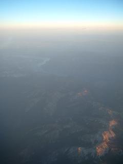
(soon) homelessness. The site of mountains in the sunset outside the aeroplane
window took our thoughts on an altogether more happy curve - "Where
do you think we should go next...?".... We
headed across to Seattle with our bikes. The bus to the airport leaves from
near University Street - we sorted this out the day before. But when we
tried to get our bikes on the bus we were told that the bike carriage zone
only begins outside of the city centre free bus zone. No doubt the city
planners can't see why anyone would want to use a bike in the city centre
when the bus is free. But if you've got a bike to get out to the suburbs
to catch a plane, the policy seems a bit dumb. A sorry look persuaded the
driver to apply commonsense, fortunately, so we were allowed on straightaway.
The ride to the airport (SeaTac) takes you through the usual US urban sprawl,
though it's interesting to see the giant hangars and offices of Boeing.
At the airport we dutifully wrapped our bike in the shredded remnants of
Guy's sleeping mat - the bubbles have been popping ever since we started
so it's now no more than a bit of tough plastic (as Steve says - the USA
has taken the bubbles out of Guy's life) - and, along with a plastic bike
bag supplied by BA (we thought these no longer existed but they do, at the
moment, in Seattle!), we wrapped up our bikes. Then we joined a ridiculously
long queue for the 'plane. BA had a little queue for Club Class and for
World Traveller Plus, but a queue that lasted two hours (of queuing time
per person) for the ordinary bulk of the passengers - World Traveller class.
Ridiculous!!! I managed to read a substantial chunk of a novel while queueing.
Hey, British Airways, why not take a tip from the deli counter at Sainsbury's
and give out numbered tickets if you're going to make people queue for such
a ridiculously long time?! A pity, since BA handled the bikes very well
and the flights were on time or early. The flight back was fun - but unfortunately
we didn't apply ourselves to the one problem that we'd been putting off
until then - what on earth do we do when we get back to joblessness and
(soon) homelessness. The site of mountains in the sunset outside the aeroplane
window took our thoughts on an altogether more happy curve - "Where
do you think we should go next...?".... |
|