Biking Across the USA - August Diary
|
|
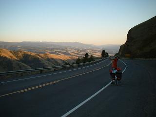
Sunday August 1st 2004
 Hatchet
Campground to Colter Bay National Park Campground - 12 miles on the transAm
route! (but there was a 28 miles detour too). Headed for the Teton Spur
- so we could get a closer look at the Teton mountains, which looked so
spectacular. We headed for Jenny Lake on the road to Jackson. There were
stunning views of the Tetons as we cycled along, as well as recommendations
to leave the bison, elk, bears, that we might see, well alone! Well, we
didn't see anything like that, for better or worse. Jenny Lake was in full
summer tourist mode - though it is a very beautiful lake at the foot of
the Grand Teton, that's a bit over 13000 feet high, and rises about 6 -
7000 feet out of the valley floor (which itself it about 6 - 7000 feet).
We had lunch, made some phone calls back home and sat by the lake. A man
asked us about our trip at the lake - and asked if we new of a little path
in northern England that goes up through Herriot Country (so to speak) to
the Scottish border. I think he meant the Pennine Way. We recommended it
to him. There were a lot of cyclists about - mostly part of organised tours.
The lake has various tourist boats on it - you can take hikes up the Tetons.
The sheer rock faces of the Tetons are incredible, with small glaciers hanging
onto the corries. On the way back we visited the Chapel of the Sacred Heart
- a log cabin church, with a rather catholic
kitsch bit of stained glass above the altar. Having a taste for such
stuff, I though it was pretty good.... Finally got to Colter Bay and set
up camp. Ate in the Campground Restaurant - pretty good, pasta, but not
particularly cheap. A nice thing about the restaurant was the endless supply
of hot water, which combined with my personal endless supply of teabags
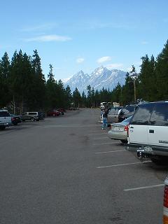
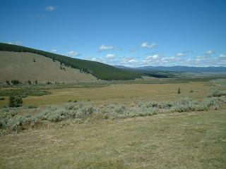
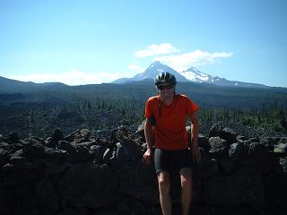
led to a great deal of happiness. Wonderful views of the Tetons across Lake
Jackson - the picture shows the view from the main area of shops at the
campground. Crossing the river that comes out of Lake Jackson we noticed
American Pelicans - great big white birds with huge beaks (traditional pelican
style), but bodies very like white swans. Hatchet
Campground to Colter Bay National Park Campground - 12 miles on the transAm
route! (but there was a 28 miles detour too). Headed for the Teton Spur
- so we could get a closer look at the Teton mountains, which looked so
spectacular. We headed for Jenny Lake on the road to Jackson. There were
stunning views of the Tetons as we cycled along, as well as recommendations
to leave the bison, elk, bears, that we might see, well alone! Well, we
didn't see anything like that, for better or worse. Jenny Lake was in full
summer tourist mode - though it is a very beautiful lake at the foot of
the Grand Teton, that's a bit over 13000 feet high, and rises about 6 -
7000 feet out of the valley floor (which itself it about 6 - 7000 feet).
We had lunch, made some phone calls back home and sat by the lake. A man
asked us about our trip at the lake - and asked if we new of a little path
in northern England that goes up through Herriot Country (so to speak) to
the Scottish border. I think he meant the Pennine Way. We recommended it
to him. There were a lot of cyclists about - mostly part of organised tours.
The lake has various tourist boats on it - you can take hikes up the Tetons.
The sheer rock faces of the Tetons are incredible, with small glaciers hanging
onto the corries. On the way back we visited the Chapel of the Sacred Heart
- a log cabin church, with a rather catholic
kitsch bit of stained glass above the altar. Having a taste for such
stuff, I though it was pretty good.... Finally got to Colter Bay and set
up camp. Ate in the Campground Restaurant - pretty good, pasta, but not
particularly cheap. A nice thing about the restaurant was the endless supply
of hot water, which combined with my personal endless supply of teabags
led to a great deal of happiness. Wonderful views of the Tetons across Lake
Jackson - the picture shows the view from the main area of shops at the
campground. Crossing the river that comes out of Lake Jackson we noticed
American Pelicans - great big white birds with huge beaks (traditional pelican
style), but bodies very like white swans.
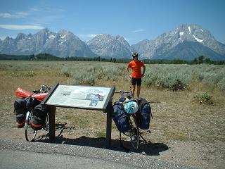 The
Tetons (the highest point is Grand Teton - the sharp summit to the left
of the picture) from the road to Jenny Lake. The
Tetons (the highest point is Grand Teton - the sharp summit to the left
of the picture) from the road to Jenny Lake.
|
|
Monday 2nd August 2004
 Colter
Bay National Park Campground to Grant Village Campground, Yellowstone National
Park. Got breakfast at the campground store and headed out onto the road
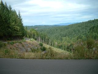
by 11am. Still not getting out early! We cycled past Jackson Lake, with
a heap of mountains on the far side - the photo shows the view along the
lake. Lots of roadworks on the road to Yellowstone - got briefly put in
the back of a pickup due to the fact that the road was a heap of stones
and rocks for a short while! Into Yellowstone National Park. Wonderful forests
some of the time - but some of the forests were a bit scorched due to a
fire in 1988. Wouldn't think many self respecting bears would want that
bit of forest. Met Brad from Boston heading to Buffalo to meet his son.
We were looking out for the wildlife, but didn't see anything notable. The
park official said, when we entered the park, that he advised against cycling
the next stretch - heavy traffic, narrow shoulder to the road, soft verges,
uphill, etc, etc. A touch absurd, presumably he was joking. Headed to the
Grant Village Campground, early on because we had heard that the campsites
in Yellowstone get very full. Arduth was camping there too. He'd saved up
three months of holiday from his job in Holland and was heading for Oregon
too. He said he liked Kansas because it was like the sea - all green waving
grass for miles. Drank some nice beer called 'Moose Drool' and went to the
very scenic pizza place right on Lake Yellowstone. Slept extremely well. Colter
Bay National Park Campground to Grant Village Campground, Yellowstone National
Park. Got breakfast at the campground store and headed out onto the road
by 11am. Still not getting out early! We cycled past Jackson Lake, with
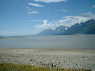
a heap of mountains on the far side - the photo shows the view along the
lake. Lots of roadworks on the road to Yellowstone - got briefly put in
the back of a pickup due to the fact that the road was a heap of stones
and rocks for a short while! Into Yellowstone National Park. Wonderful forests
some of the time - but some of the forests were a bit scorched due to a
fire in 1988. Wouldn't think many self respecting bears would want that
bit of forest. Met Brad from Boston heading to Buffalo to meet his son.
We were looking out for the wildlife, but didn't see anything notable. The
park official said, when we entered the park, that he advised against cycling
the next stretch - heavy traffic, narrow shoulder to the road, soft verges,
uphill, etc, etc. A touch absurd, presumably he was joking. Headed to the
Grant Village Campground, early on because we had heard that the campsites
in Yellowstone get very full. Arduth was camping there too. He'd saved up
three months of holiday from his job in Holland and was heading for Oregon
too. He said he liked Kansas because it was like the sea - all green waving
grass for miles. Drank some nice beer called 'Moose Drool' and went to the
very scenic pizza place right on Lake Yellowstone. Slept extremely well.
There's also a short mpeg
video clip (288Kb so suitable for 56K modems - ogg format available for
those wise enough to use linux and open source) of Guy amidst a spectacular
landscape on the road along Lake Jackson. Note that this works with either
RealPlayer or Quicktime - but Quicktime tends to default to an audio level
that is too low and makes the sound narrative (read very wittily by Guy)
jerky. Turn up the volume!
|
|
Tuesday 3rd August 2004
 Grant
Village Campground, Yellowstone National Park to West Yellowstone - 50 miles
on route. An excellent day of cycling and sight-seeing. Set off at 10am,
headed to West Thumb where we looked at the geysers - wonderful collection
of hot springs and boiling mud, etc. It's a large area which drains hot
water in Lake Yellowstone, not that the lake gets particularly warm though
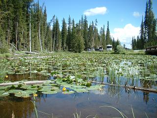
(it's c. 10 centigrade). Crossed a couple of continental divides at c. 8,300
feet, one of which had a delightful lake of waterlilies (see picture) with
water that flows both to the Pacific and the Atlantic! Then we headed down
to Old Faithful, which we waited to see - it went off twice while we were
there - the familiar jet of steam and water. Guy was to the lee of the jet
and got a dousing of cold (not hot) water. It had obviously cooled down
as it fell. The Upper Basin of geysers is very impressive, with boiling
water, mud, jets of steam and lots of remarkable rather sulphurous looking
colours and smells! Still lots of evidence of the 1988 fire. Eventually
headed to the middle geyser basin and then down the Firehole River to Madison
and eventually to West Yellowstone. Steve saw an elk grazing in dense foliage,
surrounded by photographers and park officials - a bit like a pop celebrity.
They were trying to get traffic to move on. Was the elk tame? It didn't
seem worried - just huge antlers and a brown face munching on what seemed
to be small bushes. Got to West Yellowstone and checked in at the Madinson
hostel/hotel (c. 40 dollars) as a treat. It is an excellent place - the
access to a microwave meant endless tea, etc, and the rooms are very lovely
being largely of logs. There's a nice balcony (shared) for people to sit
on and there's the chance to edit/upload photos! (this was the last time
I managed to get photos of my digital camera onto CD in the whole trip!). Grant
Village Campground, Yellowstone National Park to West Yellowstone - 50 miles
on route. An excellent day of cycling and sight-seeing. Set off at 10am,
headed to West Thumb where we looked at the geysers - wonderful collection
of hot springs and boiling mud, etc. It's a large area which drains hot
water in Lake Yellowstone, not that the lake gets particularly warm though
(it's c. 10 centigrade). Crossed a couple of continental divides at c. 8,300
feet, one of which had a delightful lake of waterlilies (see picture) with
water that flows both to the Pacific and the Atlantic! Then we headed down
to Old Faithful, which we waited to see - it went off twice while we were
there - the familiar jet of steam and water. Guy was to the lee of the jet
and got a dousing of cold (not hot) water. It had obviously cooled down
as it fell. The Upper Basin of geysers is very impressive, with boiling
water, mud, jets of steam and lots of remarkable rather sulphurous looking
colours and smells! Still lots of evidence of the 1988 fire. Eventually
headed to the middle geyser basin and then down the Firehole River to Madison
and eventually to West Yellowstone. Steve saw an elk grazing in dense foliage,
surrounded by photographers and park officials - a bit like a pop celebrity.
They were trying to get traffic to move on. Was the elk tame? It didn't
seem worried - just huge antlers and a brown face munching on what seemed
to be small bushes. Got to West Yellowstone and checked in at the Madinson
hostel/hotel (c. 40 dollars) as a treat. It is an excellent place - the
access to a microwave meant endless tea, etc, and the rooms are very lovely
being largely of logs. There's a nice balcony (shared) for people to sit
on and there's the chance to edit/upload photos! (this was the last time
I managed to get photos of my digital camera onto CD in the whole trip!).
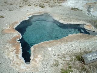 This
is a hot pool in the Old Faithful area of geysers - what a wonderful blue
colour! Don't swim in it, though, because you'd be, as has happened in
days gone by, boiled in second to a gory death. This
is a hot pool in the Old Faithful area of geysers - what a wonderful blue
colour! Don't swim in it, though, because you'd be, as has happened in
days gone by, boiled in second to a gory death.
|
|
Wednesday 4th August 2004
 Madison
Hostel/Hotel to Ennis, Camper Corner. 74 miles on route. The day didn't
start off too well with a huge rain storm that kept us in the Madison Hostel
for a while - then headed out, rain started again, and Steve got a puncture
only 4 miles down the road, which he fixed rather slowly under a bridge.
But then things improved, the wind was behind us, and we were headed down
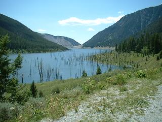
a slight downhil for many many miles. We reached Quake Lake - where the
1959 earthquake killed 28 people, commemorated on a plinth at the site.
The wooded hills are quite pretty - nice to have green, largely wooded hills
and mountains. The seismograph in the visitor centre showed that even while
we were there, there were tiny tremors - a bit alarming! In the photo you
can see, in the distance on the mountainside on the left hand side of the
valley, the scar where the earth shifted down into the valley. The wind
hurtled us on down the road to Cameron, where we ate in the cafe waiting
for a huge stormcloud to blow over - good cheap food. Then on to Ennis,
where we pitched our tent. 10 dollars for two people on bikes - I think
this was a discount rate! This was one of our fastest days on a bike - for
about 30 miles we averaged 20mph, even though there were a few uphills.
It's nice to have a following wind for a change! Bears seem to be the top
of the food chain around here - perhaps that's why the local culture likes
to have over sized everything - it makes us look a bit bigger in the scheme
of things so we aren't put in our place by the grizzly! At Ennis Camper
Corner there were a crowd of Canadian camping motor-bikers, heading to a
motorbike convention in the Dakotas somewhere. Of all the forms of motorised
transport that there are, motorbikers seem the most in touch with the cyclist.
The two species seem to understand each other well. Madison
Hostel/Hotel to Ennis, Camper Corner. 74 miles on route. The day didn't
start off too well with a huge rain storm that kept us in the Madison Hostel
for a while - then headed out, rain started again, and Steve got a puncture
only 4 miles down the road, which he fixed rather slowly under a bridge.
But then things improved, the wind was behind us, and we were headed down
a slight downhil for many many miles. We reached Quake Lake - where the
1959 earthquake killed 28 people, commemorated on a plinth at the site.
The wooded hills are quite pretty - nice to have green, largely wooded hills
and mountains. The seismograph in the visitor centre showed that even while
we were there, there were tiny tremors - a bit alarming! In the photo you
can see, in the distance on the mountainside on the left hand side of the
valley, the scar where the earth shifted down into the valley. The wind
hurtled us on down the road to Cameron, where we ate in the cafe waiting
for a huge stormcloud to blow over - good cheap food. Then on to Ennis,
where we pitched our tent. 10 dollars for two people on bikes - I think
this was a discount rate! This was one of our fastest days on a bike - for
about 30 miles we averaged 20mph, even though there were a few uphills.
It's nice to have a following wind for a change! Bears seem to be the top
of the food chain around here - perhaps that's why the local culture likes
to have over sized everything - it makes us look a bit bigger in the scheme
of things so we aren't put in our place by the grizzly! At Ennis Camper
Corner there were a crowd of Canadian camping motor-bikers, heading to a
motorbike convention in the Dakotas somewhere. Of all the forms of motorised
transport that there are, motorbikers seem the most in touch with the cyclist.
The two species seem to understand each other well. |
|
Thursday 5th August 2004
 From
Ennis Camper Corner to Dillon, Sacajawea Motel - 70 miles on route. After
breakfast in a cheap but tasty cafe on main street, and a short while updating
web pages, we headed out up the 2000 foot climb to Virginia City. This was
at times steep, but a nice steady climb and with excellent views. Downhill
a little bit to Virginia City, which is a museum piece and very interesting.
Visited library - very pleasant - and checked email. Virginia City is a
bit limited on food for cyclists - in the sense of cheap and rapid carbs,
so we pushed on and on, until we reached Alder where a cheap convenience
store solved our problem. Virginia City is a gold rush town, as most seem
to be round here. Got to Sheridan, where we hoped to find the bookshop,
coffee place and internet cafe mentioned by a transAm person in 1998 (in
their now disappeared web diary), but it had gone the way of the Dodo. Sad.
There was a bakery with very nice apple and cinnamon pastries though! In
Sheridan we watched as a young man locked himself out of the car, while
his girlfriend (?) said 'What have you done?!' . We noticed that her t-shirt
said 'I love nerds'. Well, a very understandable feeling, but clearly there
are limitations. A policeman saved the day with a quick lesson in breaking
into cars. Then on to Two Bridges, where we sheltered in the restrooms from
a large rainstorm, then on to Dillon, and a road being rebuilt. Found a
cheap motel - Sacajawea, as we got into Dillon (32.10 dollars). After a
brief visit to Safeway's down the road from the motel, we settled down with
a huge heap of food. Managed to find the BBC World News on the TV, which
was nice - most channels are very tedious and unwatchable, with endless
adverts and cheezy presenters. As is common in the USA , more choice means
less. From
Ennis Camper Corner to Dillon, Sacajawea Motel - 70 miles on route. After
breakfast in a cheap but tasty cafe on main street, and a short while updating
web pages, we headed out up the 2000 foot climb to Virginia City. This was
at times steep, but a nice steady climb and with excellent views. Downhill
a little bit to Virginia City, which is a museum piece and very interesting.
Visited library - very pleasant - and checked email. Virginia City is a
bit limited on food for cyclists - in the sense of cheap and rapid carbs,
so we pushed on and on, until we reached Alder where a cheap convenience
store solved our problem. Virginia City is a gold rush town, as most seem
to be round here. Got to Sheridan, where we hoped to find the bookshop,
coffee place and internet cafe mentioned by a transAm person in 1998 (in
their now disappeared web diary), but it had gone the way of the Dodo. Sad.
There was a bakery with very nice apple and cinnamon pastries though! In
Sheridan we watched as a young man locked himself out of the car, while
his girlfriend (?) said 'What have you done?!' . We noticed that her t-shirt
said 'I love nerds'. Well, a very understandable feeling, but clearly there
are limitations. A policeman saved the day with a quick lesson in breaking
into cars. Then on to Two Bridges, where we sheltered in the restrooms from
a large rainstorm, then on to Dillon, and a road being rebuilt. Found a
cheap motel - Sacajawea, as we got into Dillon (32.10 dollars). After a
brief visit to Safeway's down the road from the motel, we settled down with
a huge heap of food. Managed to find the BBC World News on the TV, which
was nice - most channels are very tedious and unwatchable, with endless
adverts and cheezy presenters. As is common in the USA , more choice means
less. |
|
Friday 6th August 2004
 From
Dillon, Sacajawea Motel to Jackson Hot Springs Lodge Camping Area. Headed
up over the two passes to get to Jacskson, the bigger pass was called 'Big
Hole Pass' - where the Big Hole River rises I guess. Guy saw a badger. The
roads were beautifully quiet and the scenery improved as we got higher -
the grasslands giving place to woodland. There was an excellent downhill
into the Big Hole Valley - we reached 41mph. Jackson has hot springs, so
we camped at the Hot Springs Lodge and went for a dip - it's not very romantic
because the pool is a concrete swimming pool and there are heaps of people
there. It was hot - too hot to swim for very long. Not as hot, or as delightful
a setting, as Saratoga. And the camping is a little expensive at 20 dollars.
Bought some Bitterroot Brewery beers and drank them before preceding to
Rose's Cafe and Cantina (cheaper than the Hot Springs Lodge - and seems
better value). Delicious Burritos stuffed with beans - vegetarian food.
The tune in my head today was an aria from Peter Grimes - Ellen singing
about 'We hoped to make a new start'. Guy had a song about a ship with eight
sails from Weill. Very literary today... There was a happy family reunion
going on at the Lodge - though this place seems at the end of the earth. From
Dillon, Sacajawea Motel to Jackson Hot Springs Lodge Camping Area. Headed
up over the two passes to get to Jacskson, the bigger pass was called 'Big
Hole Pass' - where the Big Hole River rises I guess. Guy saw a badger. The
roads were beautifully quiet and the scenery improved as we got higher -
the grasslands giving place to woodland. There was an excellent downhill
into the Big Hole Valley - we reached 41mph. Jackson has hot springs, so
we camped at the Hot Springs Lodge and went for a dip - it's not very romantic
because the pool is a concrete swimming pool and there are heaps of people
there. It was hot - too hot to swim for very long. Not as hot, or as delightful
a setting, as Saratoga. And the camping is a little expensive at 20 dollars.
Bought some Bitterroot Brewery beers and drank them before preceding to
Rose's Cafe and Cantina (cheaper than the Hot Springs Lodge - and seems
better value). Delicious Burritos stuffed with beans - vegetarian food.
The tune in my head today was an aria from Peter Grimes - Ellen singing
about 'We hoped to make a new start'. Guy had a song about a ship with eight
sails from Weill. Very literary today... There was a happy family reunion
going on at the Lodge - though this place seems at the end of the earth.
|
|
Saturday 7th August 2004
 From
Jackson Hot Springs Lodge Camping Area to Darby, Wilderness Motel Camping
Ground - 72 miles. A significant headwind greeted us as we took to the road!
We headed straight into Rose's cantina for a breakfast to fortify us. The
cantina has excellent food and comes complete with cycling magazines. This
seems like heaven. Eventually headed off to Wisdom - Steve led us into Wisdom,
Guy led us away from it - how appropriate! Then to Big Hole National Historic
Battlefield - a sobering bit of history in which the Nez Perce Indians were
hounded out of their homeland, and effectively interned on a small piece
of land after centuries of roaming the plains. The battle doesn't figure
high in body count compared with, say, Verdun (cycled there last year) but
it is a touching piece of history - especially today when lots of descendants
had turned up for the annual commemoration. Some people were in tears as
the events of the 1870s were retold. Some dumb biker (motorbiker) was complaining
that the Canadian flag was flying with the American flag - there were Canadian
guests there I think. What kind of nationalism is so brittle? Then on over
the pass to get into the Bitterroot Valley - downhill to Darby, where we
ate and were directed to the Wilderness Motel Campsite. 16 dollars - not
too bad for a tourist area. Also had a percolator in a common area that
we could use, so gallons of tea were drunk. From
Jackson Hot Springs Lodge Camping Area to Darby, Wilderness Motel Camping
Ground - 72 miles. A significant headwind greeted us as we took to the road!
We headed straight into Rose's cantina for a breakfast to fortify us. The
cantina has excellent food and comes complete with cycling magazines. This
seems like heaven. Eventually headed off to Wisdom - Steve led us into Wisdom,
Guy led us away from it - how appropriate! Then to Big Hole National Historic
Battlefield - a sobering bit of history in which the Nez Perce Indians were
hounded out of their homeland, and effectively interned on a small piece
of land after centuries of roaming the plains. The battle doesn't figure
high in body count compared with, say, Verdun (cycled there last year) but
it is a touching piece of history - especially today when lots of descendants
had turned up for the annual commemoration. Some people were in tears as
the events of the 1870s were retold. Some dumb biker (motorbiker) was complaining
that the Canadian flag was flying with the American flag - there were Canadian
guests there I think. What kind of nationalism is so brittle? Then on over
the pass to get into the Bitterroot Valley - downhill to Darby, where we
ate and were directed to the Wilderness Motel Campsite. 16 dollars - not
too bad for a tourist area. Also had a percolator in a common area that
we could use, so gallons of tea were drunk. |
|
Sunday 8th August 2004
 From
Darby, Wilderness Motel Camping Area to Missoula, Super Seven Motel - about
70 miles. By the end of today we've done about 3258 miles in total - on
route, but add a couple of hundred for non-route miles. Breakfasted on food
from the local gas station - frosties. More tea and then headed out onto
the road for a valley ride down the Bitterroot River valley. A fairly easy
ride though a light headwind appeared. Saw where our Bitterroot Beer had
been brewed - but didn't stop to sample since we had lots of miles still
to do. The route wanders around a bit down the valley, but we eventually
reached Lolo, and joined the dual carriageway that heads to Missoula. One
of the sponsors of litter control was, as the photo shows, 'The Drama Queens'.
Lovely! I bet you could really be a drama queen over litter! If I see another
hub cap I'm flouncing off.... The traffic was very heavy on the dual carriageway
into Missoula - on a Sunday afternoon too! I guess we are, perhaps, at the
very end of the great gasoline age - where the peak is over and we have
to find other ways to run around the planet (hope so). Hurtling along with
the heavy traffic into Missoula, we noticed that Fahrenheit 9/11 was on
at the local cinema and we also had a brew pub down for a visit. So we accepted
a crumby motel, overcharging us at 46 dollars (no air conditioning, no pets,
no parties, no third parties in rooms, no breathing after 10pm, etc, etc)
- we don't recommend the Super Seven AT ALL - and headed out to the brew
pub. It turns out that the Iron Horse Brew Pub doesn't actually brew it's
own beer. Whooops. I though that was what a brew pub was. Clearly they haven't
understood the concept. Still they had some decent beers available. From
Darby, Wilderness Motel Camping Area to Missoula, Super Seven Motel - about
70 miles. By the end of today we've done about 3258 miles in total - on
route, but add a couple of hundred for non-route miles. Breakfasted on food
from the local gas station - frosties. More tea and then headed out onto
the road for a valley ride down the Bitterroot River valley. A fairly easy
ride though a light headwind appeared. Saw where our Bitterroot Beer had
been brewed - but didn't stop to sample since we had lots of miles still
to do. The route wanders around a bit down the valley, but we eventually
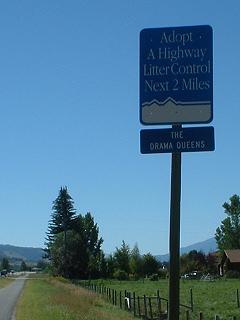
reached Lolo, and joined the dual carriageway that heads to Missoula. One
of the sponsors of litter control was, as the photo shows, 'The Drama Queens'.
Lovely! I bet you could really be a drama queen over litter! If I see another
hub cap I'm flouncing off.... The traffic was very heavy on the dual carriageway
into Missoula - on a Sunday afternoon too! I guess we are, perhaps, at the
very end of the great gasoline age - where the peak is over and we have
to find other ways to run around the planet (hope so). Hurtling along with
the heavy traffic into Missoula, we noticed that Fahrenheit 9/11 was on
at the local cinema and we also had a brew pub down for a visit. So we accepted
a crumby motel, overcharging us at 46 dollars (no air conditioning, no pets,
no parties, no third parties in rooms, no breathing after 10pm, etc, etc)
- we don't recommend the Super Seven AT ALL - and headed out to the brew
pub. It turns out that the Iron Horse Brew Pub doesn't actually brew it's
own beer. Whooops. I though that was what a brew pub was. Clearly they haven't
understood the concept. Still they had some decent beers available.
Then to the cinema. Fahrenheit 9/11 provided a humourous, shocking and
very convincing account of the use of the 9/11 events by the powers that
Bush represents. It's obvious that the recruits fighting in Iraq, drawn
from the poorest of America for the most part, are part of a resource
war that is extremely useful - resolves some of the unemployment problem,
diverts social discontent, helps Bush (and the US?) keep the oil flowing
in the 'right' direction, etc. Don't suppose it'll unseat Bush, though
it certainly should! While anyone with a heart rejoices that Saddam Hussein
has been kicked out, it's wise to be aware of the global strategy it fits
into and of the way that war, even when entered into for noble reasons,
breeds hatred and further war. Finally got back to the motel and fell
asleep very rapidly. I wrote up my web diary at the Missoula HQ of adventure
cycling the very next day - "Now we're visiting the Adventure Cycling
HQ - in Missoula, and using their internet access. See their web site
at Adventure Cycling."
|
|
Monday 9th August 2004
 From
Missoula, Super Seven Motel, to Lolo Hot Springs. About 40 miles, but most
of them uphill. The Adventure Cycling HeadQuarters is wonderful - we had
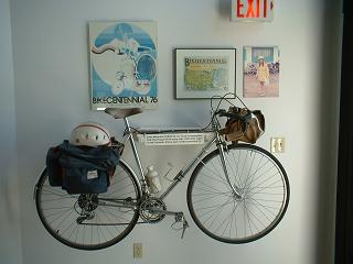
a tour and got to see various transAm memorabilia. This included the first
bike to do the transAm - a tandem - and a bike ridden in the 1976 transAm
(pictured), plus heaps of photos. We also got ice-creams and got to see
where our maps came from. Seems remarkable that they came from there to
the UK then I brought them back and there were destined to go all the way
to the Pacific and then back to the UK. Missoula has nice eateries, so we
splurged out on vegetarian Burritos and enjoyed being in a town with lots
of cyclists and a bike shop or three. We didn't get away from Missoula until
mid afternoon, then we hurried along to Lolo, where we turned up the road
for the Lolo Pass, after slogging a thousand or two feet up the pass we
came to Lolo Hot Springs, which was just too tempting to pass by. We camped
($16) and went straight into the Hot Springs - which are delicious - there's
a hot pool (too hot for Steve,just right for Guy) and a tepid pool (just
right for Steve), so we spent a while swimming and being heated like a lobster. From
Missoula, Super Seven Motel, to Lolo Hot Springs. About 40 miles, but most
of them uphill. The Adventure Cycling HeadQuarters is wonderful - we had
a tour and got to see various transAm memorabilia. This included the first
bike to do the transAm - a tandem - and a bike ridden in the 1976 transAm
(pictured), plus heaps of photos. We also got ice-creams and got to see
where our maps came from. Seems remarkable that they came from there to
the UK then I brought them back and there were destined to go all the way
to the Pacific and then back to the UK. Missoula has nice eateries, so we
splurged out on vegetarian Burritos and enjoyed being in a town with lots
of cyclists and a bike shop or three. We didn't get away from Missoula until
mid afternoon, then we hurried along to Lolo, where we turned up the road
for the Lolo Pass, after slogging a thousand or two feet up the pass we
came to Lolo Hot Springs, which was just too tempting to pass by. We camped
($16) and went straight into the Hot Springs - which are delicious - there's
a hot pool (too hot for Steve,just right for Guy) and a tepid pool (just
right for Steve), so we spent a while swimming and being heated like a lobster.
|
|
Tuesday 10th August 2004
 From
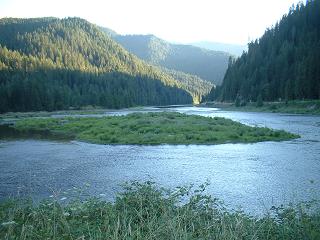
Lolo Hot Springs to Lowell, 3 rivers campground, a wonderful downhill
84 miles on route. We had breakfast in the cafe at Lolo Hot Springs, then
headed up, initially, over the Lolo Pass. It's a short climb from the
Hot Springs, though fairly steep. Then there was a wonderful downhill,
in which we stayed on the same road, along the same river, for about 70
miles of downhill. Not many places in the UK give you 70+ miles of downhill.
Anyway, it's a beautiful river - the Lochsa River, and although services
are few, the valley is wooded, with a swift broad river flowing down it.
We picked up food at Powell, and then there were no services at all, apart
from water from campgrounds, for the rest of the day. The river is very
swimmable - and the day being so hot, Steve swam in the river. It's not
that cold surprisingly - just right to be wonderfully refreshing. Eventually
we stopped at Lowell, in the 3 Rivers Campground. They sold Moose Drool
Beer, so the day ended in a haze of food and good beer. Most pleasing.
Guy looked out of the tent during the night and saw a herd of deer grazing
nearby. 3381 Miles now completed - less than a 1000 to go! From
Lolo Hot Springs to Lowell, 3 rivers campground, a wonderful downhill
84 miles on route. We had breakfast in the cafe at Lolo Hot Springs, then
headed up, initially, over the Lolo Pass. It's a short climb from the
Hot Springs, though fairly steep. Then there was a wonderful downhill,
in which we stayed on the same road, along the same river, for about 70
miles of downhill. Not many places in the UK give you 70+ miles of downhill.
Anyway, it's a beautiful river - the Lochsa River, and although services
are few, the valley is wooded, with a swift broad river flowing down it.
We picked up food at Powell, and then there were no services at all, apart
from water from campgrounds, for the rest of the day. The river is very
swimmable - and the day being so hot, Steve swam in the river. It's not
that cold surprisingly - just right to be wonderfully refreshing. Eventually
we stopped at Lowell, in the 3 Rivers Campground. They sold Moose Drool
Beer, so the day ended in a haze of food and good beer. Most pleasing.
Guy looked out of the tent during the night and saw a herd of deer grazing
nearby. 3381 Miles now completed - less than a 1000 to go!
There's a short mpeg video
clip (video ogg available too, for those sensible enough to use linux and open source)
for this stretch. We had lunch by a bridge over the river and
Steve took a video clip. Works well in RealPlayer or in QuickTime, but
be aware that Quicktime's default volume is usually too low and you'll
most likely hear just squeaks unless you turn up the volume!
|
|
Wednesday 11th August 2004
 From
Lowell, Three Rivers Campground to White Bird, Swiftwater RV/camping park.
58 miles on route, mostly uphill. Now we've done 3448 miles. Breakfast in
cafe on the main road - the usual maple syrup (or is it just high fructose
corn syrup with flavouriing?) and pancakes. Very pleasant anyhow, plus an
omlette. Headed down the valley to Kooskia, where Steve had a puncture -
well, actually the valve on the inner tube failed. This meant that we had
lunch in Kooskia, a quiet town in wooded hills. From Kooskia the road starts
off going uphill (after about 90 miles of downhill this was a bit of a shock).
Initially we followed a beautiful wooded valley upwards, then the road leaves
the river and gets much steeper. We sweated our way uphill for a couple
of thousand feet, under a boiling sun, until we reached a plateau and finally
got to Grangeville. Grangeville looked nice but we fancied doing a bit more,
so over the hill beyond Grangeville we went, and down a hurtling hill, where
we lost 3000 feet in very little time, to White Bird. We found the Swiftwater
RV/camping park on the old road. The owner had spotted us earlier on and
came back to let us in should we turn up. Which we did. She opened the shop
for long enough to buy some food, which was eaten overlooking the big and
swift river - the Salmon River I think. A very comfortable campsite (15
dollars). From
Lowell, Three Rivers Campground to White Bird, Swiftwater RV/camping park.
58 miles on route, mostly uphill. Now we've done 3448 miles. Breakfast in
cafe on the main road - the usual maple syrup (or is it just high fructose
corn syrup with flavouriing?) and pancakes. Very pleasant anyhow, plus an
omlette. Headed down the valley to Kooskia, where Steve had a puncture -
well, actually the valve on the inner tube failed. This meant that we had
lunch in Kooskia, a quiet town in wooded hills. From Kooskia the road starts
off going uphill (after about 90 miles of downhill this was a bit of a shock).
Initially we followed a beautiful wooded valley upwards, then the road leaves
the river and gets much steeper. We sweated our way uphill for a couple
of thousand feet, under a boiling sun, until we reached a plateau and finally
got to Grangeville. Grangeville looked nice but we fancied doing a bit more,
so over the hill beyond Grangeville we went, and down a hurtling hill, where
we lost 3000 feet in very little time, to White Bird. We found the Swiftwater
RV/camping park on the old road. The owner had spotted us earlier on and
came back to let us in should we turn up. Which we did. She opened the shop
for long enough to buy some food, which was eaten overlooking the big and
swift river - the Salmon River I think. A very comfortable campsite (15
dollars). |
|
Thursday 12th August 2004
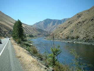 From
Swiftwater RV/Camping Park (White Bird) to Zim's Hot Springs. Campground.
A total of about 58 miles on route, once again with heaps of uphill. Breakfasting
on Cheerios is not ideal since it seems to be mostly basic sugars - but
it was all we could find suitable in the campground shop. Then we headed
up the Salmon River to Riggins, seeing various rafts going downstream. The
Salmon River is a glittering and fast river in a very parched landscape
- the photo shows the view just as you leave White Bird. We also glimpsed
a fast moving cyclist who we thought was Arduth - last spotted in Yellowstone.
Later it turned out it certainly was Arduth, who sets off early and finishes
early. The reverse of our strategy. The rafts were not very speedy - rafting
can be quite a gentle experience, clearly. Had lunch in Riggins, where we
caught up with Arduth and who was setting up camp. We also saw the aftermath
of a traffic accident - a headon collision, with ambulance taking someone
away. The roads round here bend and twist so much along the river, I guess
it's quite dangerous in a pick up truck. Then uphill, getting steeper now
we were on the Little Salmon River, to Pinehurst, where we took refuge from
110 Fahrenheit heat in a little cafe. The cafe owner chatted with us - we
are becoming familiar with the politics of the area! Logging versus conservation,
taxation issues, etc. Milkshakes and iced water were a great help. Though
the heat had declined by the time we came out of the cafe, the road deteriorated
quickly into a heap of stones - more roadworks. The dust was terribe as
the RV's swept by at speed. We kept coming to a halt in a pile of pebbles,
with no grip for the wheels. Eventually the roadworks ceased, after about
4 or 5 miles, then we reached the plateau where we saw the sign for Zim's
Hot Springs. Excellent - a hot and a tepid swimming pool. My favourite hot
springs for swimming. After all the dust and heat, it was blissful so we
spent almost two hours soaking. From
Swiftwater RV/Camping Park (White Bird) to Zim's Hot Springs. Campground.
A total of about 58 miles on route, once again with heaps of uphill. Breakfasting
on Cheerios is not ideal since it seems to be mostly basic sugars - but
it was all we could find suitable in the campground shop. Then we headed
up the Salmon River to Riggins, seeing various rafts going downstream. The
Salmon River is a glittering and fast river in a very parched landscape
- the photo shows the view just as you leave White Bird. We also glimpsed
a fast moving cyclist who we thought was Arduth - last spotted in Yellowstone.
Later it turned out it certainly was Arduth, who sets off early and finishes
early. The reverse of our strategy. The rafts were not very speedy - rafting
can be quite a gentle experience, clearly. Had lunch in Riggins, where we
caught up with Arduth and who was setting up camp. We also saw the aftermath
of a traffic accident - a headon collision, with ambulance taking someone
away. The roads round here bend and twist so much along the river, I guess
it's quite dangerous in a pick up truck. Then uphill, getting steeper now
we were on the Little Salmon River, to Pinehurst, where we took refuge from
110 Fahrenheit heat in a little cafe. The cafe owner chatted with us - we
are becoming familiar with the politics of the area! Logging versus conservation,
taxation issues, etc. Milkshakes and iced water were a great help. Though
the heat had declined by the time we came out of the cafe, the road deteriorated
quickly into a heap of stones - more roadworks. The dust was terribe as
the RV's swept by at speed. We kept coming to a halt in a pile of pebbles,
with no grip for the wheels. Eventually the roadworks ceased, after about
4 or 5 miles, then we reached the plateau where we saw the sign for Zim's
Hot Springs. Excellent - a hot and a tepid swimming pool. My favourite hot
springs for swimming. After all the dust and heat, it was blissful so we
spent almost two hours soaking. |
|
Friday 13th August 2004
From Zim's Hot Springs through to Cambridge, Idaho. 52 miles on route. Guy
went to Oxford, so it was very nice for him finally to achieve something
much better and go to Cambridge, even if Cambridge, Idaho. We set off late
(how very unusual) and had a late breakfast in New Meadows, 4 miles down
the road from Zim's. There was a wonderful conversation, soundly Republican,
going on loudly in the cafe. All the favourites were touched upon - illegal
hispanic immigrants, and taxation (did Jimmy Carter really tax people at
75%?). Very interesting to a Brit and rather like the situation in the UK
- illegal but cheap (because illegal) labour supporting staunchly Conservative/Republican
businesses... I wouldn't like to try to sort it out. After breakfast we
saw Arduth and cycled together after New Meadows for a while - from New
Meadows towards Council. We had lunch in Council, watching the trucks negotiating
the tight bend by the park (well, it's a remarkable thing in a little town
with not much going on!). Finally headed out in the 100 Fahrenheit temperature
towards Cambridge. Fortunately it was mostly downhill, so we sped along
nicely. Cambridge was a bit closed - store closed, library closed (well,
it closed just as I entered it - I was sort of hustled out at 5.45pm with
the comment that computers didn't happen after 5.45). So we were grateful
to find Bucky's Motel open, and at 35 dollars quite cheap. The US is quite
funny at times - I queued in the gas station to buy a bottle of beer, a
very large lady was buying popcorn and considering the hunting regulations
with a very large man (horizontally large that is) - you can shoot bears
apparently, this surprised me but I know nothing of their ecology. All this
whilst outside obscene rap music was spilling from a car, and several huge
RVs were trailing through town, in a cloud of dust. It's a curious juxtaposition.
|
|
Saturday 14th August 2004
 From
Cambridge (Bucky's Motel) to Halfway Motel, Campsite., Halfway - about 58
miles on route. While buying breakfast a man in a wheelchair said - 'you
on a bike?', me -> 'yes, doing coast to coast America', man ->'you
protesting about something', me->'no just seeing the USA', man->'oh,
so it's not a protest' (looking surprised), me->'no, I suppose it's for
pleasure' (sounding doubtful). I suppose we ought to be protesting about
something, still never mind. We headed up over the pass that takes you down,
down, down, into Hell's Canyon. A hot morning promising a very hot afternoon.
Stopped at the 'Gateway to Hell's Canyon' store - and got involved in a
birthday celebration. We were given cake and ice-cream! It was a 60th (or
55th - was that the real age?!) birthday for someone working in the cafe.
Such hospitality. I can't see this happening in West Yorkshire (or indeed
in the UK). The wonderful side of small town, rural, USA, is the simple
open hospitality that so frequently bubbles out of people. It was boiling
outside, but the icecream helped us set off, eventually. We got to Hell's
Canyon only to discover that someone had filled it, very thoughtfully, with
water. What an angel! So Steve had a swim in Brownlee Reservoir to cool
off. It was nice to see that the powerboat did not completely dominate the
boating scene. No, there were no sails flapping in a breeze, sadly, but
there were canoes about. The powerboats still outnumbered them, but it's
a start. After lunch in the shade by the water we headed out down the canyon
to Oxbow, then up the hill to Halfway. The valley going up to Halfway is
in Oregon! Hooray, we're in Oregon, nearly at the coast, only 600 miles
or so to go. Halfway provided a campground, at the Halfway Motel. And we
had a couple of bottles of Wheat Beer to round the day off. Very pleasant
- and just right after being scorched by the sun so much. From the position
of small town America, the USA is a sherriff seeing off the bullying desperado
Saddam Hussein, so why aren't the Iraqi's more grateful? No wonder a lot
of americans are puzzled by the world beyond their continent. From
Cambridge (Bucky's Motel) to Halfway Motel, Campsite., Halfway - about 58
miles on route. While buying breakfast a man in a wheelchair said - 'you
on a bike?', me -> 'yes, doing coast to coast America', man ->'you
protesting about something', me->'no just seeing the USA', man->'oh,
so it's not a protest' (looking surprised), me->'no, I suppose it's for
pleasure' (sounding doubtful). I suppose we ought to be protesting about
something, still never mind. We headed up over the pass that takes you down,
down, down, into Hell's Canyon. A hot morning promising a very hot afternoon.
Stopped at the 'Gateway to Hell's Canyon' store - and got involved in a
birthday celebration. We were given cake and ice-cream! It was a 60th (or
55th - was that the real age?!) birthday for someone working in the cafe.
Such hospitality. I can't see this happening in West Yorkshire (or indeed
in the UK). The wonderful side of small town, rural, USA, is the simple
open hospitality that so frequently bubbles out of people. It was boiling
outside, but the icecream helped us set off, eventually. We got to Hell's
Canyon only to discover that someone had filled it, very thoughtfully, with
water. What an angel! So Steve had a swim in Brownlee Reservoir to cool
off. It was nice to see that the powerboat did not completely dominate the
boating scene. No, there were no sails flapping in a breeze, sadly, but
there were canoes about. The powerboats still outnumbered them, but it's
a start. After lunch in the shade by the water we headed out down the canyon
to Oxbow, then up the hill to Halfway. The valley going up to Halfway is
in Oregon! Hooray, we're in Oregon, nearly at the coast, only 600 miles
or so to go. Halfway provided a campground, at the Halfway Motel. And we
had a couple of bottles of Wheat Beer to round the day off. Very pleasant
- and just right after being scorched by the sun so much. From the position
of small town America, the USA is a sherriff seeing off the bullying desperado
Saddam Hussein, so why aren't the Iraqi's more grateful? No wonder a lot
of americans are puzzled by the world beyond their continent. |
|
Sunday August 15th 2004
 From
Halfway Motel, Camping Area to Baker City, Baker City Motel Camping Area.
A hilly day of about 54 miles. Met Phil Hinricks, doing transAm West to
East (and expecting to finish in October) - doing this after retiring from
his job. He's done the transAm before, many years ago. Looks fit - a young
retiree. Two Oregonians (I want to say Oreganos!) recommended some locations
to camp on the coast - very helpful! We set off rather late, over the pass
above Halfway, in hot sun. Then down into Richland to buy lunch - Guy noticed
the transAm sticker on the grocery store door. Very faded and clearly dating
from a while back - could it be an original 1976 sticker? A holy relic to
us anyway. Then up the big climb of the day - through a very empty landscape,
mostly just dry hills and sagebrush, with no shops, water, or anything.
We found a bit of shade on the climb, so we then had lunch. Then more uphill,
past the Oregon Trail Historic Interpretative Centre (not too catchy that
name) - which was closing as we arrived (often the case) - though that saved
us the steep climb up to it. Then downhill into Baker City for a pleasant
chinese meal (tofu - a favourite) at Jimmy Chan's Chinese Restaurant on
Main Street and a campsite at the Baker City Motel. We've complete 3670
miles, the coast is getting closer. I sometimes think I can hear seagulls.
Wrote up this section of the diary in Baker City library, which was brilliant
with heaps of books, computers, and cool air. In the library I wondered
- "But we've a big hill to do today - can we reach Prairie City? It's
about 2500-ish feet of climbing from here". From
Halfway Motel, Camping Area to Baker City, Baker City Motel Camping Area.
A hilly day of about 54 miles. Met Phil Hinricks, doing transAm West to
East (and expecting to finish in October) - doing this after retiring from
his job. He's done the transAm before, many years ago. Looks fit - a young
retiree. Two Oregonians (I want to say Oreganos!) recommended some locations
to camp on the coast - very helpful! We set off rather late, over the pass
above Halfway, in hot sun. Then down into Richland to buy lunch - Guy noticed
the transAm sticker on the grocery store door. Very faded and clearly dating
from a while back - could it be an original 1976 sticker? A holy relic to
us anyway. Then up the big climb of the day - through a very empty landscape,
mostly just dry hills and sagebrush, with no shops, water, or anything.
We found a bit of shade on the climb, so we then had lunch. Then more uphill,
past the Oregon Trail Historic Interpretative Centre (not too catchy that
name) - which was closing as we arrived (often the case) - though that saved
us the steep climb up to it. Then downhill into Baker City for a pleasant
chinese meal (tofu - a favourite) at Jimmy Chan's Chinese Restaurant on
Main Street and a campsite at the Baker City Motel. We've complete 3670
miles, the coast is getting closer. I sometimes think I can hear seagulls.
Wrote up this section of the diary in Baker City library, which was brilliant
with heaps of books, computers, and cool air. In the library I wondered
- "But we've a big hill to do today - can we reach Prairie City? It's
about 2500-ish feet of climbing from here". |
|
Monday 16th August 2004
 From
Baker City (Baker City Motel Camping Site) to Prairie City, County Campground.
About 69 miles on route - we are now about 500 miles from our terminus in
Astoria! It was raining when we emerged from our tent. We packed up quickly
and headed for a cafe to get some breakfast - as usual, pancakes with maple
syrup (or lookalike substance, more like!) along with an omelette. Then
we headed out to do some shopping at Safeway, since there isn't very much
apart from mountains and woods on our route today. Then we got to the library
- and we got a bit delayed. Left Baker City very late - c. 1pm. Seemed a
bit unlikely that we'd get to Prairie City - 69 miles. Anyhow, we headed
uphill along a river valley out of Baker City, up past a dam, then up through
very pleasant wooded country towards the three passes that are between Baker
City and Prairie City. We stopped for lunch at the Sumpter Valley Railway
station that was just off our route - a railway restoration project. The
line ran from the 19th Century through to the 1930s - as a passenger line,
and more recently as just a freight enterprise. It's the usual history of
logging and mining. Ate lunch, then just as we were leaving we saw two cyclists
overtaking us! Oops, we'd been overtaken by Jake (has a 'blog')
and Didi (short for Deitmar), who are going super fast (this was one of
their 100+ mile days) towards the Oregon coast. They certainly energised
us, because the three passes to Prairie City shot by, even though evening
was coming on. From
Baker City (Baker City Motel Camping Site) to Prairie City, County Campground.
About 69 miles on route - we are now about 500 miles from our terminus in
Astoria! It was raining when we emerged from our tent. We packed up quickly
and headed for a cafe to get some breakfast - as usual, pancakes with maple
syrup (or lookalike substance, more like!) along with an omelette. Then
we headed out to do some shopping at Safeway, since there isn't very much
apart from mountains and woods on our route today. Then we got to the library
- and we got a bit delayed. Left Baker City very late - c. 1pm. Seemed a
bit unlikely that we'd get to Prairie City - 69 miles. Anyhow, we headed
uphill along a river valley out of Baker City, up past a dam, then up through
very pleasant wooded country towards the three passes that are between Baker
City and Prairie City. We stopped for lunch at the Sumpter Valley Railway
station that was just off our route - a railway restoration project. The
line ran from the 19th Century through to the 1930s - as a passenger line,
and more recently as just a freight enterprise. It's the usual history of
logging and mining. Ate lunch, then just as we were leaving we saw two cyclists
overtaking us! Oops, we'd been overtaken by Jake (has a 'blog')
and Didi (short for Deitmar), who are going super fast (this was one of
their 100+ mile days) towards the Oregon coast. They certainly energised
us, because the three passes to Prairie City shot by, even though evening
was coming on.
We arrived in the dark, more or less, at Prairie City. We just got into
a cafe before it ceased serving, explored the idea of camping in the park
(turns out this is not at all acceptable to the local community so best
not do that!),and ended up in the official, paying, campsite. We shared
a beer or two with Didi and Jake (exploring the options for free camping
in a cooperative local citizens garden and so sitting in a gazebo when
we met them, so as to avoid being soaked), until the local police officer
(he must have been having a dull day!) informed us that this counted as
a 'beer party' in a gazebo and must therefore cease quickly. Well, it
ceased. The rain was pouring down at this point - I can't imagine a less
threatening group than four soaked cyclists sharing some beers, but...
Sleep was not too good, the rain kept restarting its downpour, then easing
off. Prairie City is a curious place - most places welcome cyclists by
saying, sleep in our park, use our local shops, you are good for us, we
are good for you - but I don't think this mentality has yet percolated
through to Prairie City. Just down the road at Dayville, where I used
the church computer for free, the mentality is the reverse and immensely
hospitable, as has been the predominant and wonderful pattern across the
USA.
|
|
Tuesday 17th August 2004
 From
the County Campground, Prairie City, through to Dayville, Presbyterian Church
- a massive journey of, well, 41 miles. We returned our empty beer bottles
(6 bottles amongst 4 people - a big beer party clearly) to the store, as
you get a refund on them in Oregon. The newspaper has statistics making
clear that most people don't do this, and that recycling is pretty static
in Oregon - not growing much at all. Certainly the reaction of the store
owner did seem a little surprised. Do they recycle them, return them, or...
throw them in the trash? We can only speculate. Nice to have 30 cents back
though. It was raining, but looked like brightening up. Steve did the Sumpter
Valley Railroad museum, which houses a nice collection of memorabilia, some
railroad related, some just relating to the area. The railroad from here
to Sumpter was really something - climbing three times over the 4000 foot
contour. The big local family who had done well were represented - and an
odd but stimulating collection of curious objects - including lots of gold
mine pictures from happy days when gold was to be found in quantities in
the local hills. We eventually cycled down to John Day - named after a local
farmer and general entrepreneur. Even the river here is named "John Day".
An excessively large lunch kept us in the park for some time (we were hoping
to swim but the pool was densely packed with writhing small children), and
it was pretty late when we finally made it to Dayville. The Presbyterian
church offers hospitality to bikers, so we took them up on their offer.
It is an amazingly generous offer - including showers, use of a kitchen
and computer (where I am now) and space to sleep. I like this sort of Christian
witness! Thanks Dayville Presbyterians! We heard that Didi and Jake are
racing towards Mitchell - another 40 - 50 miles away. Anyhow, that was tomorrow
for us. I typed "So I'm signing off, sleepy with pasta, tea (this is
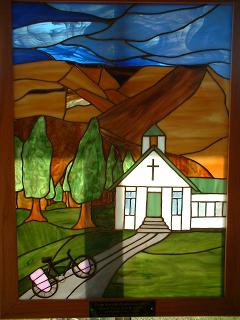
an alcohol free church) and typing!". A good place to be. The photo
shows a piece of stained glass that is in the church hall - as you can see,
a bicycle is going to church. Well, with this sort of hospitality maybe
people would think there was something worth turning up at church for! Jesus
would ride a bike if he were going from A to B today! From
the County Campground, Prairie City, through to Dayville, Presbyterian Church
- a massive journey of, well, 41 miles. We returned our empty beer bottles
(6 bottles amongst 4 people - a big beer party clearly) to the store, as
you get a refund on them in Oregon. The newspaper has statistics making
clear that most people don't do this, and that recycling is pretty static
in Oregon - not growing much at all. Certainly the reaction of the store
owner did seem a little surprised. Do they recycle them, return them, or...
throw them in the trash? We can only speculate. Nice to have 30 cents back
though. It was raining, but looked like brightening up. Steve did the Sumpter
Valley Railroad museum, which houses a nice collection of memorabilia, some
railroad related, some just relating to the area. The railroad from here
to Sumpter was really something - climbing three times over the 4000 foot
contour. The big local family who had done well were represented - and an
odd but stimulating collection of curious objects - including lots of gold
mine pictures from happy days when gold was to be found in quantities in
the local hills. We eventually cycled down to John Day - named after a local
farmer and general entrepreneur. Even the river here is named "John Day".
An excessively large lunch kept us in the park for some time (we were hoping
to swim but the pool was densely packed with writhing small children), and
it was pretty late when we finally made it to Dayville. The Presbyterian
church offers hospitality to bikers, so we took them up on their offer.
It is an amazingly generous offer - including showers, use of a kitchen
and computer (where I am now) and space to sleep. I like this sort of Christian
witness! Thanks Dayville Presbyterians! We heard that Didi and Jake are
racing towards Mitchell - another 40 - 50 miles away. Anyhow, that was tomorrow
for us. I typed "So I'm signing off, sleepy with pasta, tea (this is
an alcohol free church) and typing!". A good place to be. The photo
shows a piece of stained glass that is in the church hall - as you can see,
a bicycle is going to church. Well, with this sort of hospitality maybe
people would think there was something worth turning up at church for! Jesus
would ride a bike if he were going from A to B today! |
|
Wednesday 18th August 2004
 From
Dayville, Presbyterian Church to Ochoco Lake campground (National Forestry
Service) - about 80 miles on route. We actually got on the road by 9am!
Well, it does help if you haven't got a tent to pack up. Then we headed
off up the first big climb of the day - which got almost immediately postponed
because of the John Day Fossil Beds - a wonderful near desert area full
of fossils. The fossils date from after the dinosaurs, when the whole area
went through a series of dramatic climatic changes - with lava flowing in
regularly to freeze the animals and plants in a thick layer of preservative.
Fascinating collection of skulls - from the horse's early relatives, strange
rhino like creatures. The landscape is also very impressive - gorges in
a near desert, with bands of different rock very clear on the 3000 foot
mountains. The view from the visitor centre was pretty good - see photo.
Eventually we got going again, headed over the Keyes Pass, then down into
Mitchell (for a second lunch) - where we met Carmando heading East. Well,
he might make Virginia by November - though he could do part of the route
and leave some more for another year. Carmando seemed like a traditional
Californian to us - likeable, super relaxed and extremely well preserved
for his years (which weren't very many anyway). Then on to the Ochoco Pass,
which was a steep and brisk climb. We really had to push down the hill from
the pass in order to arrive at the Ochoco Lake just as the last cafe was
closing - they were kind enough to stay open long enough to serve us food
outdoors while they closed up the cafe. Then we camped at the lakeside -
the camp host was someone who had given up entirely on bricks and mortar
and now had only an RV for a home (well, that and a caravan) - the ultimate
in mobility (so long as gasoline is cheap!). is this the future - just as
real estate prices peak, the age of stable real estate might come to an
end? Nice though - there is a theory, of course, that humans are essentially
nomadic (Bruce Chatwin's theory, I think, for one) and so having a permanent
settlement is not too good for you. Doesn't stop house prices going up ludicrously
though. From
Dayville, Presbyterian Church to Ochoco Lake campground (National Forestry
Service) - about 80 miles on route. We actually got on the road by 9am!
Well, it does help if you haven't got a tent to pack up. Then we headed
off up the first big climb of the day - which got almost immediately postponed
because of the John Day Fossil Beds - a wonderful near desert area full
of fossils. The fossils date from after the dinosaurs, when the whole area
went through a series of dramatic climatic changes - with lava flowing in
regularly to freeze the animals and plants in a thick layer of preservative.
Fascinating collection of skulls - from the horse's early relatives, strange
rhino like creatures. The landscape is also very impressive - gorges in
a near desert, with bands of different rock very clear on the 3000 foot
mountains. The view from the visitor centre was pretty good - see photo.
Eventually we got going again, headed over the Keyes Pass, then down into
Mitchell (for a second lunch) - where we met Carmando heading East. Well,
he might make Virginia by November - though he could do part of the route
and leave some more for another year. Carmando seemed like a traditional
Californian to us - likeable, super relaxed and extremely well preserved
for his years (which weren't very many anyway). Then on to the Ochoco Pass,
which was a steep and brisk climb. We really had to push down the hill from
the pass in order to arrive at the Ochoco Lake just as the last cafe was
closing - they were kind enough to stay open long enough to serve us food
outdoors while they closed up the cafe. Then we camped at the lakeside -
the camp host was someone who had given up entirely on bricks and mortar
and now had only an RV for a home (well, that and a caravan) - the ultimate
in mobility (so long as gasoline is cheap!). is this the future - just as
real estate prices peak, the age of stable real estate might come to an
end? Nice though - there is a theory, of course, that humans are essentially
nomadic (Bruce Chatwin's theory, I think, for one) and so having a permanent
settlement is not too good for you. Doesn't stop house prices going up ludicrously
though. |
|
Thursday 19th August 2004
From
Ochoco Lake campground (National Forestry Service) to Lava Lake Campground
(or Lava Lamp Cakeground, after a bottle of the local brew!) - a distance
of a about 65 miles (almost all of them uphill). Went across road from the
campsite to get breakfast - which sadly was not the usual mass of carbohydrate
rich food, but frankly rather small (the pancakes were the smallest we've
seen so far). Anyhow, after this, and a quick visit to the Lake, we finally
set off. It was a short run to Prineville where we had a second breakfast
(required due to the smallness of our first breakfast). Then we headed on
through a long wide dry canyon to Redmond. The day was hot and sunny, and
the riding seemed easy. Redmond is another of those towns in the midst of
a real estate boom - so everywhere seemed to be offering little places for
only a very reasonable price (ho ho). We headed rapidly out of Redmond and
over to Sisters. Before reaching Sisters we had the good fortune to pass
the very pleasant Kline (Cline?) Falls - where Steve had a swim in the river
and we ate lunch. The water was just right, not too cold at all. It's a
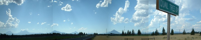
popular place for a river swim on a hot day. As we got near to Sisters the
mountains seemed particularly impressive - all the peaks of the Cascades
were spread out to north and south - something like the panoramic photo
above (click on the photo for a more detailed photo - 750Kb). Sisters was
OK - it's the kind of place that would rather sell you a scented candle
than food or drink, so it's not really that much use to someone on a bike,
but it does have a decent grocery store (Ray's, just after the turning for
the McKenzie Pass that we were going to take). A heap of food was bought
since there's not much at the campground at the top of the pass. We headed
up the pass in increasing gloom as the sun set. We got a bit confused by
the campground sign - it said 'Lava Camp Lake' - well, is that the campground
sign or just for the lake? Steve preferred to read the sign as "Lava Lamp
Cake" anyway. So we ignored it, reached the top of the pass and realized
that we should have taken the turning. We finally reached the campsite in
semi-darkness. There's no water at the campground so we had only 1.5litres
of water each, but that's enough. The night was so black that it was very
easy to see huge numbers of stars - I don't think we've ever seen the milky
way so visible as from 5000 feet up at the Lava Lamp Cakeground. Wonderful.
It was also wonderful to have an excellent salad, with olives and red wine,
in such a remote location. |
|
Friday 20th August 2004
 From
Lava Lake Campground to Super 6 Motel, Eugene. A distance of about 80 miles
on the transAm route. We finally passed the 4000 mile mark today, so we
are within a couple of hundred miles of finishing the transAm official route,
and within perhaps 400 - 500 miles of finishing our route at the airplane
in Seattle. We breakfasted on granola bars and then headed, once again,
up to the top of the pass. What a wonderful place! The sea of lava stretchs
for miles either side - now looking like a huge ash heap - broken rocks,
strange shapes on every side. In the distance to the south the Three Sisters,
with snow on their summits, cut into the horizon, and to the north there's
the Belknapp Crater (responsible for all this mess of old lava) and Mt Washington,
with a good covering of snow, plus various smaller mountains. I took so
many photos the batteries on the camera started to fade (and am unable to
upload them immediately because in Newport, Oregon, they're a bit paranoid
about letting you put any CDs into the computers, sadly). We needed to get
going though, so after a little while we started going downhill, which we
continued to do for the next 30 or so miles! Our biggest downhill, as we
went from 5000' to the coastal plain level of circa 1000'. To make up for
a minimal breakfast we had two lunches, one in McKenzie Bridge and one in
Blue River. I've never seen so many huge RVs as passed us on the downhill
ride along the 126 towards Eugene. They are like dinosaurs ripe for extinction
in my opinion.... Eugene is an excellent town, and we found a cheap-ish
motel (about 40 dollars for the two of us). There didn't seem to be a campsite
really near the downtown shops, etc, so it was hard to avoid. There's a
hostel for not much less - and without the perk of a tiny swimming pool
to cool off in. Eugene is, I think, the most livable town we have been through
in the USA (not that we've been through very many that big!) - nice location,
quite green, relatively controlled sprawl, only 1hr or so from the coast,
and a university town with a generally open feeling. We went to the McMenamins
Brew Pub (which actually does brew - as the name seems to require...) and
saw the local headquarters of the stop
resolution 36campaign. Oregon is currently arguing about whether to
ban gay marriage - seems a curious thing to want to do in a country that
is, apparently, all about freedom and liberty. Clearly this is a liberty
too far for some people. As a philosophically inclined person, the idea
of 'defining' marriage by statute seemed a bit humpty-dumpty-esque to me.
If the meaning is the use, then it means whatever the extended community
of communities that is America do with the word. Surely the state shouldn't
be taking advice from the churches about how to define what surely is, in
the US, a secular legal arrangement. Is the US becoming a theocracy (silly
thought!)? Anyhow, I like the campaign to stop the amendment to the state's
constitution that will prevent (?) any gay marriages in Oregon. Freedom
is a slippery thing, I guess, but you generally know when you haven't got
it. Eventually we returned to our room, having learnt something about the
politics of the state we were in. From
Lava Lake Campground to Super 6 Motel, Eugene. A distance of about 80 miles
on the transAm route. We finally passed the 4000 mile mark today, so we
are within a couple of hundred miles of finishing the transAm official route,
and within perhaps 400 - 500 miles of finishing our route at the airplane
in Seattle. We breakfasted on granola bars and then headed, once again,
up to the top of the pass. What a wonderful place! The sea of lava stretchs
for miles either side - now looking like a huge ash heap - broken rocks,
strange shapes on every side. In the distance to the south the Three Sisters,
with snow on their summits, cut into the horizon, and to the north there's
the Belknapp Crater (responsible for all this mess of old lava) and Mt Washington,
with a good covering of snow, plus various smaller mountains. I took so
many photos the batteries on the camera started to fade (and am unable to
upload them immediately because in Newport, Oregon, they're a bit paranoid
about letting you put any CDs into the computers, sadly). We needed to get
going though, so after a little while we started going downhill, which we
continued to do for the next 30 or so miles! Our biggest downhill, as we
went from 5000' to the coastal plain level of circa 1000'. To make up for
a minimal breakfast we had two lunches, one in McKenzie Bridge and one in
Blue River. I've never seen so many huge RVs as passed us on the downhill
ride along the 126 towards Eugene. They are like dinosaurs ripe for extinction
in my opinion.... Eugene is an excellent town, and we found a cheap-ish
motel (about 40 dollars for the two of us). There didn't seem to be a campsite
really near the downtown shops, etc, so it was hard to avoid. There's a
hostel for not much less - and without the perk of a tiny swimming pool
to cool off in. Eugene is, I think, the most livable town we have been through
in the USA (not that we've been through very many that big!) - nice location,
quite green, relatively controlled sprawl, only 1hr or so from the coast,
and a university town with a generally open feeling. We went to the McMenamins
Brew Pub (which actually does brew - as the name seems to require...) and
saw the local headquarters of the stop
resolution 36campaign. Oregon is currently arguing about whether to
ban gay marriage - seems a curious thing to want to do in a country that
is, apparently, all about freedom and liberty. Clearly this is a liberty
too far for some people. As a philosophically inclined person, the idea
of 'defining' marriage by statute seemed a bit humpty-dumpty-esque to me.
If the meaning is the use, then it means whatever the extended community
of communities that is America do with the word. Surely the state shouldn't
be taking advice from the churches about how to define what surely is, in
the US, a secular legal arrangement. Is the US becoming a theocracy (silly
thought!)? Anyhow, I like the campaign to stop the amendment to the state's
constitution that will prevent (?) any gay marriages in Oregon. Freedom
is a slippery thing, I guess, but you generally know when you haven't got
it. Eventually we returned to our room, having learnt something about the
politics of the state we were in. |
|
Saturday 21st August 2004
 Eugene
Super 6 to Alsea Falls, BLM Campground - about 40 miles not quite on, but
not entirely off, route. We diverted from the main route in order to experience
the sheer freedom of the wandering cyclist. Well, we headed out of Eugene
along the cycle path by the river to the north west, then we reached Junction
City, then Monroe, then went up a little road to the Alsea Falls (it's a
climb, particularly at the start, see the photo), because it looked like
a nice place to camp and would mean we could finally reach the coast the
next day. On the way out of Eugene, a rather underused machine in an excellent
supermarket on the road north out of Eugene put all my digital pictures
onto CD (though this turned out not to be a CD that works in any CD player
I've yet come across!). Most helpful, but sadly this library doesn't do
CDs but they will turn up on here very soon! Camping at Alsea Falls was
excellent - it's a sort of primordial forest, with huge stumps of trees,
and dripping with rain when we were there. Sadly the weather has worsened.
We hadn't planned so well, and so dinner was pretty small. Went to sleep
when the light faded. Eugene
Super 6 to Alsea Falls, BLM Campground - about 40 miles not quite on, but
not entirely off, route. We diverted from the main route in order to experience
the sheer freedom of the wandering cyclist. Well, we headed out of Eugene
along the cycle path by the river to the north west, then we reached Junction
City, then Monroe, then went up a little road to the Alsea Falls (it's a
climb, particularly at the start, see the photo), because it looked like
a nice place to camp and would mean we could finally reach the coast the
next day. On the way out of Eugene, a rather underused machine in an excellent
supermarket on the road north out of Eugene put all my digital pictures
onto CD (though this turned out not to be a CD that works in any CD player
I've yet come across!). Most helpful, but sadly this library doesn't do
CDs but they will turn up on here very soon! Camping at Alsea Falls was
excellent - it's a sort of primordial forest, with huge stumps of trees,
and dripping with rain when we were there. Sadly the weather has worsened.
We hadn't planned so well, and so dinner was pretty small. Went to sleep
when the light faded. |
|
Sunday 22nd August 2004
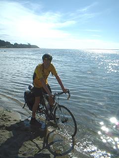 From
Alsea Falls, BLM Campground to South Beach State Park Campground, Newport.
A distance of about 66 miles on our own variant on the transAm route. We
went to Alsea to have breakfast - about 10 miles up the road. Ate breakfast
outside the store - two soaked cyclists eating raisin bran and yoghurt in
the rain. Still, it isn't cold at least. Then along the road to the coast
at Waldport. Wonderful - the sun came out and Steve dipped his tyres in
the Pacific in the sparkling water. And after about 4100 miles we had made
it across the USA. We've still got to get to Astoria for the sake of history
and the official transAm route, and then to Seattle. But it's nice to have
reached the coast. After celebratory ice cream, we went up the coast to
Newport - because someone at a bike shop in Eugene said it was their favourite
coastal location. Well, we arrived as the sun set in a huddle of cloud over
the sea. The sea is, though, remarkably cold, even by British standards.
Similar to the coastal temperatures off the north of Scotland I'd guess!
The surf isn't particularly good at the moment - blown around and choppy
due to an onshore wind. We ate our evening meal in Lee's Wok - a Chinese
Restaurant in the splurge of untidy development that extends along the coast
road 101. It's got a good vegetarian section on the menu. From
Alsea Falls, BLM Campground to South Beach State Park Campground, Newport.
A distance of about 66 miles on our own variant on the transAm route. We
went to Alsea to have breakfast - about 10 miles up the road. Ate breakfast
outside the store - two soaked cyclists eating raisin bran and yoghurt in
the rain. Still, it isn't cold at least. Then along the road to the coast
at Waldport. Wonderful - the sun came out and Steve dipped his tyres in
the Pacific in the sparkling water. And after about 4100 miles we had made
it across the USA. We've still got to get to Astoria for the sake of history
and the official transAm route, and then to Seattle. But it's nice to have
reached the coast. After celebratory ice cream, we went up the coast to
Newport - because someone at a bike shop in Eugene said it was their favourite
coastal location. Well, we arrived as the sun set in a huddle of cloud over
the sea. The sea is, though, remarkably cold, even by British standards.
Similar to the coastal temperatures off the north of Scotland I'd guess!
The surf isn't particularly good at the moment - blown around and choppy
due to an onshore wind. We ate our evening meal in Lee's Wok - a Chinese
Restaurant in the splurge of untidy development that extends along the coast
road 101. It's got a good vegetarian section on the menu. |
|
Monday 23rd August 2004
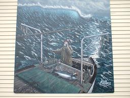 Newport
to Newport - 0 miles! (well, a few miles around town). We visited the Rogues
Brewery Co., and sampled a small amount of their products. Seems wonderful
- Chocolate Stout, etc, etc. The Yaquina Head lighthouse is very impressive
- and we've been in the Yaquina Bay lighthouse - beautifully restored. I'm
now in the public library at Newport, where my time at the computer is about
to run out! Sadly no photos can be uploaded from this library... nor does
the Kodak CD onto which I thought I was managing to put my photos seem to
have any of the photos I've taken! We also had a wander around the Harbour
area of Newport - which is a bit like Whitby in England. The most impressive
thing about the area are the large paintings on the walls of the buildings
- see the photo of a wave surfing fishing boat! More chinese food in the
evening, as the rain set in heavily again. We're having our first day off
since leaving Washington, DC, 67 days ago. But we'll be on the road again
very soon - if only to complete the route to the Astoria and then on to
Seattle. Newport
to Newport - 0 miles! (well, a few miles around town). We visited the Rogues
Brewery Co., and sampled a small amount of their products. Seems wonderful
- Chocolate Stout, etc, etc. The Yaquina Head lighthouse is very impressive
- and we've been in the Yaquina Bay lighthouse - beautifully restored. I'm
now in the public library at Newport, where my time at the computer is about
to run out! Sadly no photos can be uploaded from this library... nor does
the Kodak CD onto which I thought I was managing to put my photos seem to
have any of the photos I've taken! We also had a wander around the Harbour
area of Newport - which is a bit like Whitby in England. The most impressive
thing about the area are the large paintings on the walls of the buildings
- see the photo of a wave surfing fishing boat! More chinese food in the
evening, as the rain set in heavily again. We're having our first day off
since leaving Washington, DC, 67 days ago. But we'll be on the road again
very soon - if only to complete the route to the Astoria and then on to
Seattle. |
|
Tuesday 24th August 2004
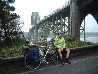 From
Newport to Bunny's Campground, Neskowin Creek. A very damp cycle ride that
had so many detours within it that we failed to get to Pacific City (still
10 miles to go) and could only get as far as Neskowin Creek by the time
it was getting quite dark. After breakfast we tackled the bridge into Newport,
again, see the photo - there's a howling wind up on that bridge and there's
very limited room for bikes! We visited an excellent bookshop on the harbour
bay area of Newport, where Steve bought some easy fiction in the form of
the cat mysteries of Lydia Adamson + Mark Twain's Roughin It. Then on to
lunch (! yes a bit early but that's due to getting up late due to rain),
then on to the Yaquina Head Lighthouse, which was wonderful on a wild and
windy day especially. Interestingly, the lighthouse doesn't have rooms in
its tower - its hollow with just a spiral staircase. It's the tallest lighthouse
in Oregon. We'd hoped to see whales off the headland, but in the prevailing
conditions - heavy continual rain with mist - there's little chance of seeing
a seagull more than 200 yards away. We met Sebastian, a cyclist going from
Edmonton (Canada) to Argentina, taking a year over it, and keeping a web
log - but only in German and Finnish. Then on via Lincoln City to Neskowin
Creek. Lincoln City is an endless development that spills along the coast
road and has little to recommend it. It's on a par with Skegness in England,
endless burger joints and heavy traffic. In the distance the tide retreats
twice daily in shame at the horrible mess. There could clearly be some very
good surf around here. We were very grateful to find a campground as the
light disappeared, and Bunny's Campground has a swimming pool - indoor -
so we swam, and we had bought some food in Lincoln City so we ate well! From
Newport to Bunny's Campground, Neskowin Creek. A very damp cycle ride that
had so many detours within it that we failed to get to Pacific City (still
10 miles to go) and could only get as far as Neskowin Creek by the time
it was getting quite dark. After breakfast we tackled the bridge into Newport,
again, see the photo - there's a howling wind up on that bridge and there's
very limited room for bikes! We visited an excellent bookshop on the harbour
bay area of Newport, where Steve bought some easy fiction in the form of
the cat mysteries of Lydia Adamson + Mark Twain's Roughin It. Then on to
lunch (! yes a bit early but that's due to getting up late due to rain),
then on to the Yaquina Head Lighthouse, which was wonderful on a wild and
windy day especially. Interestingly, the lighthouse doesn't have rooms in
its tower - its hollow with just a spiral staircase. It's the tallest lighthouse
in Oregon. We'd hoped to see whales off the headland, but in the prevailing
conditions - heavy continual rain with mist - there's little chance of seeing
a seagull more than 200 yards away. We met Sebastian, a cyclist going from
Edmonton (Canada) to Argentina, taking a year over it, and keeping a web
log - but only in German and Finnish. Then on via Lincoln City to Neskowin
Creek. Lincoln City is an endless development that spills along the coast
road and has little to recommend it. It's on a par with Skegness in England,
endless burger joints and heavy traffic. In the distance the tide retreats
twice daily in shame at the horrible mess. There could clearly be some very
good surf around here. We were very grateful to find a campground as the
light disappeared, and Bunny's Campground has a swimming pool - indoor -
so we swam, and we had bought some food in Lincoln City so we ate well!
One of the oddest things about cycling the transAm has been how quickly
life goes from the very pits to heaven, all within the space of a few
minutes. One moment you are battling with heavy rain and its getting dark,
the next minute you are floating in warm water, with a warm(-ish) sleeping
bag ready for you. It makes you grateful for very small things - the warmth
of a fragment of sunshine, the coolness of cool water, the kindness of
driver's being understanding when the windswept cyclist doesn't seem entirely
in control of his bicycle. The rain had been endless recently - just three
days now of almost continual rain. The coast is beautiful, just very very
wet. We were assured that this is a break in a run of warm sunny weather
that they were having.
|
|
Wednesday 25th August 2004
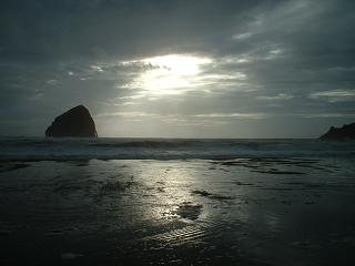 Neskowin
Creek to Pacific City - 10 miles. Well we finally reached where we'd intended
to reach yesterday. The rain has continued. I'm about to be timed out at
thepublic library in Pacific City. I've been looking at my favourite medium
range weather site and I've noticed
that they believe a high pressure area will establish itself just off the
Oregon coast. Well, I sincerely and profoundly hope they are right. We've
still got a few hundred miles to do before returning to England! Enjoying
reading a book for a significant amount of time - not something we've done
for the past two months. Lydia Adamson's Cat mysteries are lightweight flim
flam, but very amusing. I've also got Roughing It by Mark Twain, recommended
by Mark Stewart of Mark and Wanda, to enlighten me on what it was like to
be part of all those gold rushes, etc, that we've seen evidence of as we've
crossed the western USA. We've also discovered that there is a brewery nearby
- Pelican Brewery - and we plan to do some quality control. Neskowin
Creek to Pacific City - 10 miles. Well we finally reached where we'd intended
to reach yesterday. The rain has continued. I'm about to be timed out at
thepublic library in Pacific City. I've been looking at my favourite medium
range weather site and I've noticed
that they believe a high pressure area will establish itself just off the
Oregon coast. Well, I sincerely and profoundly hope they are right. We've
still got a few hundred miles to do before returning to England! Enjoying
reading a book for a significant amount of time - not something we've done
for the past two months. Lydia Adamson's Cat mysteries are lightweight flim
flam, but very amusing. I've also got Roughing It by Mark Twain, recommended
by Mark Stewart of Mark and Wanda, to enlighten me on what it was like to
be part of all those gold rushes, etc, that we've seen evidence of as we've
crossed the western USA. We've also discovered that there is a brewery nearby
- Pelican Brewery - and we plan to do some quality control.
We're still planning how we get from Astoria to Seattle - suggestions
welcome, we think we'll be doing the coast probably. ...Later - well the
Pelican Brewery is very good as far as the beer goes - we sampled the
various beers and decided it was a close run thing with the Rogues Brewery
back in Newport, but that the Rogues Brewery did actually brew the best
beers. The Pelican Brewery is fairly new (1998 seems to be the official
start of it) and so it may have some catching up to do. Eating there was
pleasant, not cheap, and curious in that the music is superbly dull, being
Beach Boys and the like, all too much the familiar US of postcards and
fake gift shoppes. The waitresses are pleasant but perhaps a little more
curious about how to divide up the tips than to promote real ales - ours
frankly admitted her ignorance of real ale. Well, I suppose you just can't
get the staff... Comments to bradfordbikes@yahoo.com
|
|
Thursday 26th August 2004
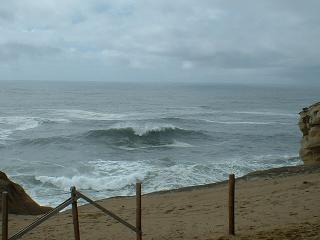 Pacific
City - Pacific City - 0 miles. A day for exploring that area of damp and
rain that is the Pacific Coast of Oregon. Actually it was raining so heavily
I hde so far finished one mystery by Lydia Adamson and was well into Roughin
It by Mark Twain, finding a great deal of similarity between the US in
the late 19th Century and now! It's a very amusing read, anyhow. Guy got
some new shorts in the Thrift Shop in Pacific City - he was asked where
he was staying by another customer. He said he was camping. The man looked
non-plussed. Guy repeated that he was camping. The man asked 'Are you
staying long?'. I'm starting to think that in the American scheme of things
there's homeowners, in stable houses, then there's flat dwellers perhaps,
along with public housing dwellers, and then there's 'trailer park trash'
and then there's the camper! Are we slipping off the end of the US social
scale? Looking forward to a bit of a ride up the coast tomorrow! Could
we see whales? We went for a walk up the headland to the north of Pacific
City, where large waves were battering the sandy cliffs - as in the photo. Pacific
City - Pacific City - 0 miles. A day for exploring that area of damp and
rain that is the Pacific Coast of Oregon. Actually it was raining so heavily
I hde so far finished one mystery by Lydia Adamson and was well into Roughin
It by Mark Twain, finding a great deal of similarity between the US in
the late 19th Century and now! It's a very amusing read, anyhow. Guy got
some new shorts in the Thrift Shop in Pacific City - he was asked where
he was staying by another customer. He said he was camping. The man looked
non-plussed. Guy repeated that he was camping. The man asked 'Are you
staying long?'. I'm starting to think that in the American scheme of things
there's homeowners, in stable houses, then there's flat dwellers perhaps,
along with public housing dwellers, and then there's 'trailer park trash'
and then there's the camper! Are we slipping off the end of the US social
scale? Looking forward to a bit of a ride up the coast tomorrow! Could
we see whales? We went for a walk up the headland to the north of Pacific
City, where large waves were battering the sandy cliffs - as in the photo.
If, like Steve, waves are a bit of a fascination for you, see short mpeg
video clip (304Kb so just about OK for 56K modems - video ogg for those wise enough to use
linux and open source) of the sea state,
with commentary! Quicktime usually plays this with the volume too low,
so if that's what you use, turn up the volume to hear the commentary.
|
|
Friday 27th August 2004
Pacific City - Pacific City - 0 miles. Again! Due to the heat evident
when getting up this morning, discipline collapsed and the ride up the
coast towards Astoria was postponed in order to see if a) there was surf
worth examining more closely (tho' most probably with a solid winter wetsuit
as part of the bargain), b) to see if I, Steve, could get through half
of Mark Twain's Roughin' It, and c) to see if either of us could pluck
up enough courage to immerse ourselves in the Pacific Ocean in any way
whatsoever, cold and chilly as it appears to be (and we're used to Scarborough,
Skegness and Anglesey - not exactly known for their high sea temperatures!).
Steve is a bit shocked by the news that his favourite, most beloved, folk
group are splitting up - banoffi, from Whitby. See their web
site, listen to their music, it's, well, gorgeous. So now we're building
up to an afternoon on the beach. After today though, discipline will return
and we will get nearer to Astoria, the official finish to our transAm.
Everything soaked by the three to four days of rain is now dry! Hooray!
|
|
Saturday 28th August 2004
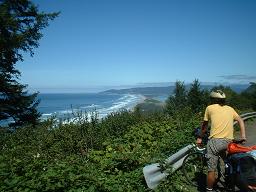 From
Pacific City to Nehalem Bay, which is about 60 miles on route. Initially
felt a bit sad to leave Pacific City, because the surf seemed to be shaping
up. This may well have been a very temporary phenomena, since due to the
coolness of the sea (I reckon it's about 12 or 13 centigrade at the moment
- compared with a nice 15 or 16 centigrade at a typical sandy beach in mid
Wales or at Skegness) there's often a strong afternoon sea breeze, and a
bit of sea mist coming onshore, which pretty much spoils the surf. We need
to go some miles, though, and very pleasant miles they are too between Pacific
City and Nehalem Bay - most of them are not on the coastal route 101 and
so not so heavily trafficked. We started off with a big breakfast at "The
Coffee Shoppe" in Pacific City (at about 11am, a bit late as usual), which
was busy and understandably so - it does excellent pancakes and omelettes.
Then on the Three Capes route - which is part of the Oregon Coast Bike Route,
as are sections of Highway 101. The Three Capes were not too difficult -
the first cape is the biggest, coming from the south. We got some wonderful
views of crashing waves on distant beaches alongside the capes. Then we
eventually reached Oceanside, which had no store so we ate at a cafe. Oceanside
is a delightful seaside resort - small and manageable. We then went through
Tillamook - a big town, but we didn't stop since it was starting to get
a bit late! We then decided to take the quiet route up the Miami River Valley,
so as to avoid the busyness of the coastal highway. About a couple of miles
along the route, a car tried to force Guy off the road, and actually nudged
his bike, the driver tried the same thing with me. And then accelerated
away at speed. Unfortunately we didn't get the registration details - it
was just a speeding saloon car of a rather dull colour! The whole incident
was very surprising given the politeness that's been common here in the
USA towards bikes - better than on the crowded roads of Britain. Eventually
we reached Nehalem village - where we bought food. In the store where I
was buying food, a youth was buying cigarettes, saying he was buying them
for younger (underage smokers) friends. The shop lady looked on with an
odd indulgence. She seemed a bit far gone. Anyhow, she sold me some food,
which we ate at the Nehalem Bay State Park - only 8 dollars for two bikers
and a tent. The beach is huge and with the wind that was blowing should
have had one or two, at least, windsurfers exploring the waves. After a
look at the sunset, we read books until late. I'm hurtling through Roughing
It by Mark Twain. From
Pacific City to Nehalem Bay, which is about 60 miles on route. Initially
felt a bit sad to leave Pacific City, because the surf seemed to be shaping
up. This may well have been a very temporary phenomena, since due to the
coolness of the sea (I reckon it's about 12 or 13 centigrade at the moment
- compared with a nice 15 or 16 centigrade at a typical sandy beach in mid
Wales or at Skegness) there's often a strong afternoon sea breeze, and a
bit of sea mist coming onshore, which pretty much spoils the surf. We need
to go some miles, though, and very pleasant miles they are too between Pacific
City and Nehalem Bay - most of them are not on the coastal route 101 and
so not so heavily trafficked. We started off with a big breakfast at "The
Coffee Shoppe" in Pacific City (at about 11am, a bit late as usual), which
was busy and understandably so - it does excellent pancakes and omelettes.
Then on the Three Capes route - which is part of the Oregon Coast Bike Route,
as are sections of Highway 101. The Three Capes were not too difficult -
the first cape is the biggest, coming from the south. We got some wonderful
views of crashing waves on distant beaches alongside the capes. Then we
eventually reached Oceanside, which had no store so we ate at a cafe. Oceanside
is a delightful seaside resort - small and manageable. We then went through
Tillamook - a big town, but we didn't stop since it was starting to get
a bit late! We then decided to take the quiet route up the Miami River Valley,
so as to avoid the busyness of the coastal highway. About a couple of miles
along the route, a car tried to force Guy off the road, and actually nudged
his bike, the driver tried the same thing with me. And then accelerated
away at speed. Unfortunately we didn't get the registration details - it
was just a speeding saloon car of a rather dull colour! The whole incident
was very surprising given the politeness that's been common here in the
USA towards bikes - better than on the crowded roads of Britain. Eventually
we reached Nehalem village - where we bought food. In the store where I
was buying food, a youth was buying cigarettes, saying he was buying them
for younger (underage smokers) friends. The shop lady looked on with an
odd indulgence. She seemed a bit far gone. Anyhow, she sold me some food,
which we ate at the Nehalem Bay State Park - only 8 dollars for two bikers
and a tent. The beach is huge and with the wind that was blowing should
have had one or two, at least, windsurfers exploring the waves. After a
look at the sunset, we read books until late. I'm hurtling through Roughing
It by Mark Twain. |
|
Sunday 29th August 2004
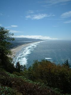 Nehalem
Bay State Park to Seaside (Circle Creek Campground). Packed up and headed
for breakfast in Mazanita (Spanish for 'little apple' apparently). Another
place where breakfast at weekends is an institution - so had to wait a bit.
Eventually headed off along coast road, with a detour to Cannon Beach to
each lunch (which was all too soon after breakfast). Cannon beach is, of
course, so named because a British cannon washed up there way back, when
they were working out the relative merits of Oregon versus bits of Canada
and who should have which bits, etc. The shop where I bought lunch was a
bit of a curiosity - very very heavy rock was blaring out inside the shop
proclaiming death, destruction and the imminent apocalypse. When the shopkeeper,
who bore a resemblance to Thor [reddish hair and huge] said "is it a bit
loud?" I said "no but the singer could do with a throat pastille" (yes,
the old ones are the best aren't they?).The photo was taken from a headland
a bit before Cannon Beach, looking back over Nehalem Bay (that bit of blue
going inland in the distance). Got to Seaside, which is by the sea surprisingly
enough. There's only one campsite near Seaside it seems and that's the one
we went to. It's not cheap at 16 dollars for a basic campsite, without a
table (which costs a grand 3-4 dollars more). This campsite seems to be
making use of its monopoly position! We ate the cyclist's standby of an
all you can eat salad at Pizza Hut. The Hut was in a sad state - listless
staff and a general air of couldn't care much! Finally set up camp at the
site (after not realising that the campsite office was open, because it
had a big notice saying closed on it - it was really open and we should
have paid our fees immediately rather than proceeding to set up camp) and
fell asleep. Even Seaside's library was a bit tricky - I was pushed off
the computers all too soon. Nehalem
Bay State Park to Seaside (Circle Creek Campground). Packed up and headed
for breakfast in Mazanita (Spanish for 'little apple' apparently). Another
place where breakfast at weekends is an institution - so had to wait a bit.
Eventually headed off along coast road, with a detour to Cannon Beach to
each lunch (which was all too soon after breakfast). Cannon beach is, of
course, so named because a British cannon washed up there way back, when
they were working out the relative merits of Oregon versus bits of Canada
and who should have which bits, etc. The shop where I bought lunch was a
bit of a curiosity - very very heavy rock was blaring out inside the shop
proclaiming death, destruction and the imminent apocalypse. When the shopkeeper,
who bore a resemblance to Thor [reddish hair and huge] said "is it a bit
loud?" I said "no but the singer could do with a throat pastille" (yes,
the old ones are the best aren't they?).The photo was taken from a headland
a bit before Cannon Beach, looking back over Nehalem Bay (that bit of blue
going inland in the distance). Got to Seaside, which is by the sea surprisingly
enough. There's only one campsite near Seaside it seems and that's the one
we went to. It's not cheap at 16 dollars for a basic campsite, without a
table (which costs a grand 3-4 dollars more). This campsite seems to be
making use of its monopoly position! We ate the cyclist's standby of an
all you can eat salad at Pizza Hut. The Hut was in a sad state - listless
staff and a general air of couldn't care much! Finally set up camp at the
site (after not realising that the campsite office was open, because it
had a big notice saying closed on it - it was really open and we should
have paid our fees immediately rather than proceeding to set up camp) and
fell asleep. Even Seaside's library was a bit tricky - I was pushed off
the computers all too soon. |
|
Monday 30th August 2004
Seaside to Seaside - 0 miles. A day for exploring Seaside.We tried the library
but it's closed on Mondays. So instead we explored the used bookstore, almost
opposite. This tempted Guy into a book on Learning Polish and another book
equally obscure. Steve almost purchased abook by Simone de Beauvoir, but
looking at his panniers made him reconsider - they are stuffed overfull
as it is. So I'm thinking about it... We visited the surf shop on Highway
101 in town and I looked at surf rental. Didn't sound like there was much
good surf - blown about by an onshore breeze. The surfers recommended mornings,
before the wind gets going. When we then went to the seashore we discovered
that the sea looked very like Skegness - a bright breezy and choppy sort
of sea, not a majestic Pacific Ocean, with gently but powerfully crumbling
waves that originated somewhere near Japan (Steve's fantasy). The afternoon
on the beach was fun - Roughing It by Twain and a cat mystery by Lydia Adamson
were polished off, Guy being in the midst of Welsh Grammar. I went in the
sea and swam. This was against the advice posted on the various lifeguard
posts - which declared the sea to be rough. Well, not by Lincolnshire standards
it isn't! It was chilly - I've since been told that the temperature out
at sea is around 52 Fahrenheit. It wasn't quite that cold in the shallows.
Nobody hangs about fully immersed, I've noticed - it's a sea to play in,
but get out of frequently to warm up a bit. People wear wetsuits if they
are going to stay in very long. Finished the day with Chinese food on Highway
101 and a beer (Obsidian Stout from Deschuttes, very impressive). |
|
Tuesday 31st August 2004
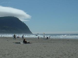 Another
seaside day. 0 miles on route, though a few miles cycling in a big circle
around Seaside. Another dip in a chilly sea. It's fascinating to see the
mist coming in from the cold sea and evaporating over the hot land, where
it eventually gathers into clouds a bit inland (or over Tillamook Head).
The air has plenty of moisture, and the cold sea air meeting the hot inland
seems to make for a fair bit of mist, which gathers over the mountains inland.
The coast has a surprising lack of surfers, windsurfers, etc. I guess it's
a bit cold for the average bod. The onshore winds are not a happy phenomenon
for surfers, but where are the windsurfers? At work I suppose, or at the
Gorge inland, where the thermal winds hurtle along a choppy river. Another
seaside day. 0 miles on route, though a few miles cycling in a big circle
around Seaside. Another dip in a chilly sea. It's fascinating to see the
mist coming in from the cold sea and evaporating over the hot land, where
it eventually gathers into clouds a bit inland (or over Tillamook Head).
The air has plenty of moisture, and the cold sea air meeting the hot inland
seems to make for a fair bit of mist, which gathers over the mountains inland.
The coast has a surprising lack of surfers, windsurfers, etc. I guess it's
a bit cold for the average bod. The onshore winds are not a happy phenomenon
for surfers, but where are the windsurfers? At work I suppose, or at the
Gorge inland, where the thermal winds hurtle along a choppy river. |
|
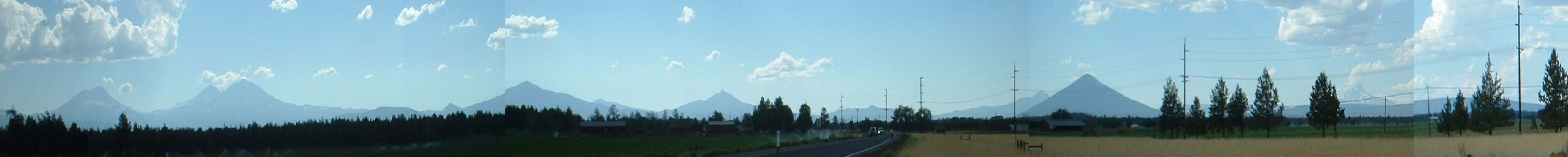